The islands lining Breton Sound took a beating during Hurricane Ivan, and offer very different fishing options from years past.
When hurricane Ivan spared the majority of the population of Southeast Louisiana last fall, it certainly did the Breton and Chandeleur Island chain no favors.In making a turn of a few degrees and putting the white-sand beaches of the “Redneck Riviera” in its crosshairs, Ivan still gave the long island chain a battering as bad as Hurricane Georges did several years ago.
Breton Island was probably the least affected, in that it still had some girth to its sandy beaches and plant life making up the Breton Island National Wildlife Refuge. No doubt it’s changed a lot, but nothing compared to the islands to the north making up what used to be somewhat of a sacred playground for seaplane pilots Billy Good and Gibby Andry.
“We’ve probably lost seventy percent of our fishing area for all but the very calmest of days,” said Andry, an 11-year seaplane pilot. “We’re really realizing right now how much we took it for granted back then. Now, much of the Chandeleurs look like Mother Nature took a rake to it.”
Good was making a routine check of the plane — Andry’s 1981 Cessna 185 straight float plane (as opposed to an amphibious model featuring wheels) — when I pulled up to Southern Seaplane. Andry wasn’t far behind and their well-practiced, though textbook-serious banter regarding safety put me at ease after exchanging pleasantries.
Good was Andry’s instructor in getting his license to pilot seaplanes, and the two have been best friends since their early years.
“If everybody driving a car had to keep up their vehicle in the same condition and put forth the same effort we do in regards to safety with these planes, there’d be no wrecks,” said Andry. “The FAA doesn’t play around at all. They make sure everything’s tight.”
True enough, this trip had been postponed once already — a prospect that churns the stomach of a writer on deadline — due to a small low-pressure system, which could have produced thunderstorms as well as a wind ill-suited for the prospects of smoothly placing the pontoons in protected water.
“The last thing I want to do is to have your first trip on the plane be a bumpy one where we have to start dodging things out there,” said Andry on the phone, an hour and a half before I was to make my way down Highway 23.
Part of me wanted to experience the whole package — for about half a second, until I remembered the little motion sickness “issue” that crops up every now and then.
Soon, we were making our way southeast, almost immediately crossing the Mississippi River at Caernarvon and taking in the view of Big Mar, Lake Lery and the Delacroix marsh at 500 feet and 110 knots.
Communication is a funny thing in a small aircraft. A newcomer such as myself has as many questions as tour guides like Good and Andry have bullets of information, but our exchanges were reduced to me tapping them on the shoulder and myself peeling away my face from the window when Good turned around to share something.
I strained to spot a redfish in the broken marsh beyond the End of the World marina before forcing myself to relax. Andry assured me that a school of bronze-backs awaited at the island, and with any luck, we’d be able to land near them, hop out and cast into the mayhem.
When he’s not patrolling the bridges, reef balls and platforms of Lake Pontchartrain, you can often find Capt. Van Joffrion of Shad Rig Charters guiding anglers out of the Chandeleur Islander, a houseboat anchored in the harbor of Breton Island.
Joffrion takes a bit different approach than the seaplane-goers do, preferring to split his charters into wade fishing and fishing from his 22-foot Cobia bay boat around the island’s bottom structure.
Change from season to season is the rule rather than the exception, but this year’s differences are especially profound, though many have already been repaired by the dredge working to save the island from fracturing further.
Near the top of the list was a breach in the main part of the island near where the old Kerr McGhee facility used to stand.
“Michele (manager of the Islander) said it was several hundred feet across,” Joffrion said. “It’s now repaired, and one of the new features that seems to have gone along with that repair is a new bar on the surf side of the island.
“I would guess it’s around 80 to 100 yards off of the beach right off of where they did the repair, which is directly across from where the Islander is sitting. One of my customers waded out in its direction, and said there was at least five feet of water where he was standing, but that there were waves breaking offshore. And, of course, it’s going to be a little smoother between the sand and the bar.
“The bar connecting the islands, aside from the channel on the West Point side, is all under water. There may be a few spots at low tide that are exposed, but not much. There are also a few new deep holes washed out behind West Point, and they’ve really been holding a lot of trout.”
Though there is still a north point of the island — the end of the island opposite of West Point, or what many call Bird Island — Joffrion estimates that 70 percent of the point, which made a classic barrier island J-curve, is gone. It’s on the Gulf side of this point that exists some of the island’s best structure, a mushy patch of bottom peppered by eroded stubble of some kind.
“That’s going to take a little more time to find now, but it really is some of the best structure to fish. It can usually be found by looking for some dirty sand on some of the calmer days,” said Joffrion.
Dirty sand is a bit more prevalent these days as the dredge charged with the job of repairing the island is, in the short term, murking things up with constantly changing outflow locations.
“We’re always looking for the clearest water available, being that we can get a good idea of it from the air,” said Andry. “The dredge’s discharge has been a big factor in the water clarity.”
For pilots such as Andry and Good, the lack of landing space and prevalence of dirty water can add up to an iffy trip to Breton. They used to have an outstanding ace in the hole to the north with Grand Gosier, Little Gosier and Curlew Island, but the past several years’ procession of tropical systems has really done a number on the smaller islands to the north.
“The farther north you go in the chain, the less influence from the Mississippi River it has and the clearer the water gets,” Andry said. “We were, not too long ago, able to find a protected shore on either of those islands and land (the plane). Now, it takes a super calm day for Grand Gosier and Curlew, and Little Gosier is nothing but a sandbar.”
As we made our way into Black Bay, there were sights every step of the way. Center-consoles rode the 10-knot east wind back toward terra firma, a lone pogie boat rushed to finish its chores as three others steamed north, where the spotter plane had located a school. Porpoises made the hair on my neck stand at attention in wonder for a moment as they gulped air.
I wished I had more than a rudimentary knowledge of the Black Bay/Breton Sound structure make-up so that I could ID them. There was even a subtle color change complete with a line of sargassum around three miles from the island.
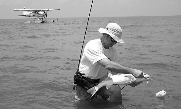
Suddenly, we were there. A mere 40 action-packed minutes from the large drainage canal serving as Southern Seaplane’s landing strip was Breton Island.
Immediately, it was evident that Bird Island was a shell of its former self, with roughly half of the mass contained in the island being actual land. The sandbar extending to the other part of the island was still sandy, but an underwater bar now. And the beautiful hook germane to most barrier islands on North Point was missing.
“This is what we’re talking about. Unless we’ve got a real calm day, you’ve got very few options,” said Good over the engine’s din. “Unless we see some fish, we’re going to show you Gosier and Curlew now.”
What Good didn’t say was that the trip north would likely be a sight-seeing adventure only. With the breeze and the limited protection offered by the islands, the chances of landing the plane were slim.
Of course, all of that was just details. I was enjoying every second, every new stretch of water released for viewing by the sun on our starboard side. A quartet of adventurous vessels were anchored on the inside of North Point, and a few of the Islander’s flat boats were secured on the bar while its anglers tried their luck on the beach.
We were quickly on Little Gosier, which was simply a light spot in the increasingly green water. A few sharks cruised the outside edges, but other than that, it was mainly devoid of life upon first glance.
“There are some pilots who say they can see trout, but I don’t believe it. They’re just too dark,” said Andry. “Redfish, on the other hand, show up beautifully. They’re usually in schools of 40-50 fish. Usually, they’re either 5- to 8-pound fish or 8- to 12-pound fish. Fifteen pounds is the biggest I’ve seen.
“But it’s not just the redness that shows up. A lot of times, the blue on their tails really shows up, too.
“Three to five hundred feet is the best altitude to view them. Any lower, and it’s kind of like looking into a pool right at water level. If you stand up, you’re going to be able to see, say, a quarter at the bottom of the pool.”
Grand Gosier had a little more life, with a few more sharks and stingrays, but it was nothing to compare it to the spectacle awaiting us at Curlew. Hundreds of sharks circled the island, including a decidedly bigger and lighter bull shark pointed out by both men. Bat rays were interspersed with their barbed relatives, and we caught a glimpse of what could well have been a school of reds. We made two passes, but couldn’t positively identify them and moved on. It was time to fish.
We made one last pass in search of a school of reds, careful to stay off of the island so as to not disturb the birds, and began our descent. Soon, we were banging gently on the half foot chop as the submerged bar grew closer and closer.
Good secured the plane, and we hopped into the cool, green water. The tide wasn’t moving much, a concern somewhat to Andry for my interests, but clearly and blissfully secondary to him.
“This is the real fly fishing. Fishing out here, to me, is lagniappe,” said Andry. “We usually don’t spend a lot of time on the water out here, especially compared to the people in boats.”
Andry, having the decided advantage of a bird’s eye view, first and foremost looks for fish. Second is finding clean water. Only after this is bottom structure taken into consideration.
While safety is of the utmost concern before a trip, there’s always a chance that things will go sour on the way back. To say that Andry and Good keep an eye to the sky is an understatement.
“We take every precaution before we make it out there. I check with Southern Seaplane, I talk with people on the radio, we monitor the weather services on the internet, occasionally we check with PHI and have them check the radar,” said Andry. “Once we’re out here, it’s a lot different. We keep an eye on things, making sure the tide doesn’t go out on the plane, but most of all, if the wind comes up or if things start to bubble up back to the east, we’re out of here immediately.”
Joffrion also offered some safety tips for visitors to the island.
“The storm seemed to move a lot of the sand from the island to the harbor,” he said. “It’s a little tricky getting out from where the houseboats are. The Islander has marked the channel with white PVC poles with green crab trap floats.”
Fortunately, despite the increasing wind, there was no reason on the horizon to rush from the island. We made it across the bar and into the green water, Andry with a gold Johnson Sprite, Good with a Top Dog and me with the basics of a purple/chartreuse Bayou Chub minnow.
Good got a few strikes, but most were just tire-kickers and he soon switched to a jig under a rattle cork.
A lone 7-pound red startled the heck out of me with a slashing strike at my jig seconds before I was to pick it up. The fish had its way for a while with the light trout rod, but soon was weakly circling.
I tried to relax in securing the fish, but it had to have looked like I was desperately trying to show Good and Andry just how much surf-fishing I had done in the past.
The red somehow made it onto the stringer, but the trout were a different story as Good and I both lost plump 18-inch fish in the unforgiving swells and lack of a net and gunnels.
Action was slow after that as Andry and I walked back to the plane to grab my camera.
“The tide always plays a big part of things out here. A falling tide is always the best and that’s what it’s supposed to be doing right now. There’s just not much of it,” he said. “I’ve been out here when we spotted a beautiful school of reds on a slack tide. They were all around us when we waded out to them, and they wouldn’t touch a lure. We could have tried to tackle them and had a better chance at catching one.”
The east breeze made the return trip much faster, and it was punctuated by an extended tour of the marsh around Reggio as well as spying around a dozen hogs in a power line clearing in between the river and Belle Chasse Highway.
The steep — to me at least — banking of the small plane upon sighting required me to subtly grab the air-sickness bag for a moment, but soon the pigs were gone before my stomach could churn any further.
All thoughts of the Venice flu halted when Andry — Good was manning the controls on the way back — looked back and told me to look to the left of the plane.
“An F-15 is about to take off,” he said.
As the fighter jet jumped into the air from Callendar Field and the slide show of immediate memories played back in my mind, it became apparent exactly why these guys don’t mind a short trip in the water one bit. n
Southern Seaplane offers seaplane charters, and can be reached at 504-394-5633. Capt. Van Joffrion of Shad Rig Charters can be reached at 985-646-0519.
