In past years, Louisiana’s central coast was known for producing lots and lots of school trout. But recent big fish catches are turning anglers’ eyes toward the marshes of lower Terrebonne Parish.
The Barataria Land Bridge is that piece of real estate bordered by Bayou Lafourche on the west and the Mississippi River on the east, the southern shoreline of Lake Salvador to the north, and having the northern portion of Little Lake as the southern boundary.
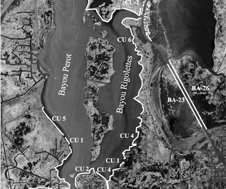
South of the land bridge, the percentage of open-water area increases greatly as one moves southward toward Barataria Bay and Grand Isle. Probably the most critical portions of the land bridge are the southern regions of Bayous Perot and Rigolettes, where they neck down prior to entering the Harvey Cutoff and Little Lake.
The Barataria Bay Waterway (BBW) just east of this area also is an important tidal connection that bisects the land bridge and affects the Barataria Bay estuary.
The Barataria Land Bridge was identified early in the Coastal Wetlands Planning, Protection and Restoration Act (CWPPRA) process as a critical land form to help protect the upper portions of the Barataria Basin from saltwater intrusion and excessive tidal actions. If maintained as an intact landform, it may also help protect the developed areas around Lafitte and the west bank of New Orleans from storm surges associated with the passage of tropical depressions and hurricanes.
Unfortunately, that piece of Louisiana real estate is experiencing the highest shoreline erosion rates in the state. Research funded by the Louisiana Department of Natural Resources (LDNR) has indicated that from 1985 to 1990, shoreline erosion along the southern portions of Bayous Perot and Rigolettes ranged from a low of 25 feet per year to a high of 238 feet per year.
The 1990 to 1995 rates ranged from 49 feet per year to 170 feet per year, with an average of 90 feet per year.
As these waterways become wider, the distance over which waves can be generated grows longer, and higher waves result. As such, it is likely that these rates would actually increase in the future, lacking any action being taken by the restoration community.
The shoreline of the BBW also has experienced significant erosion over the years. The eastern bank of the channel just south of Lafitte essentially disappeared in the 1980s. Since the marsh south of the Pen and adjacent to the waterway had already largely disappeared prior to that happening, the loss of that shoreline created a large open-water area that allows storm surges to move inland with little resistance.
Beginning in 1992, the CWPPRA program, with the leadership of Jefferson Parish and the Natural Resources Conservation Service (NRCS), authorized the first project to address shoreline erosion on a portion of the land bridge.
That effort, called the Jonathan Davis project (CU-2 and CU-3 on the accompanying map), is addressing shoreline erosion problems along the upper portion of Bayou Rigolettes from where it enters the BBW south of Lafitte westward across the northeastern shoreline of Bayou Perot to the Gulf Intracoastal Waterway
Following in the footsteps of the Jonathan Davis project, similar efforts were authorized on the western bank of the BBW in 1994 and on the eastern bank of the BBW in 1996. Additionally, various shoreline segments along Bayous Perot and Rigolettes and portions of Harvey Cutoff and upper Little Lake were authorized for construction and/or engineering and design in 1998, 1999, 2000, 2002 and 2004.
The Jonathan Davis project is partially complete, with the remainder of the project scheduled to go to construction this year. At times, redfish, speckled trout and flounder can all be caught by fishing the rocks that make up this erosion control feature.
The work along both shorelines of the BBW has been completed. Due to poor soil loading capabilities on the eastern shoreline of the BBW, the NRCS was concerned that rock rip-rap would just sink out of sight. Therefore, they decided to try something different. The final CWPPRA project design consisted of the placement of a sheet of geotextile fabric on top of the mud (to help distribute the weight), upon which was placed a lightweight aggregate enclosed in geotextile fabric bags. This aggregate consists of an expanded clay that is created by exposing clay materials to intense heat. The expanded clay is only slightly heavier than water. The bags containing the aggregate were then capped with rock to hold them in place.
So far, only 28,000 feet of structural protection benefitting the shorelines of Bayous Perot and Rigolettes have been installed, with an additional 11,000 feet presently under construction.
Due to concerns about poor soil conditions, NRCS and LDNR constructed test sections of several shoreline-protection ideas in the area, and determined that, where very poor soil conditions were found, a concrete sheetpile wall supported on pilings driven deep into the mud would be utilized.
In all, those projects approved adjacent to Bayous Perot and Rigolettes include about 66,500 feet of concrete sheetpile wall, 78,500 feet of rock rip-rap shoreline revetment and about 4,500 feet of rock riprap foreshore dike (a rock dike located in the water paralleling a shoreline intended for protection).
The majority of these shoreline-protection features include “fish dips” at strategic locations to allow juvenile and adult fish and crustaceans (and fishermen) to move between the waterways and the marsh.
Construction for the remainder of the shoreline protection effort in the vicinity of Bayous Perot and Rigolettes is scheduled to begin as follows: 28,800 feet (CU-6) in July of 2004; 31,600 feet (CU-4) in August of 2004, 19,300 feet (CU-3) in December 2004 and 31,500 feet (CU-5) in July of 2005.
Each construction unit is expected to take up to a year to complete, and total cost of all the projects currently estimated at $66 million.
Richard Hartman is the leader of the Louisiana office of the Habitat Conservation Division of NOAA Fisheries.
