Planned diversions generate controversy
Louisiana’s planned and existing diversion projects continue to yield controversy, but they’re not a one-size-fits-all approach.
In recent public forums about the state’s Master Plan for the coast, any and all discussions dealing with diversion projects have been drenched by controversy and strife.
While those from academia and government have been Johnny-on-the-spot with explanations about the benefits, commercial fishing interests and some coastal residents have filled the role of Debbie Downer by offering counter arguments.
The two sides of the debate, however, aren’t mutually exclusive; there are some scientists and biologists who are highly skeptical of diversion projects and, inversely, there are some working fishermen who consider them a cure-all.
That’s all to say you can find boosters and naysayers of all stripes on both sides.
Yet there are some commonly used fallacies from the pros and the cons in this developing disputation that deserve clarification and further study. While those in the proverbial weeds on this topic might have the basics down pat, others not intimately familiar with concepts like erosion rates and subsidence effects might benefit from a primer of sorts.
This is especially true in regard to diversion projects, not only for their current volatility as a public policy issue, but also due to their size and scope.
The state is currently involved with two types of diversion projects: freshwater and sediment.
These different approaches can be confused due to similarities — such as the fact that they both carve out presences along the coast, and they are used to transport natural cargo from inland to the Gulf of Mexico’s edge.
But the approximations stop there.
Freshwater diversions pull water and nutrients with no salinity from a river or other water body and deposit them into the wetlands using gates, siphons and other mechanisms to control the flow.
Overarching goals includes offsetting saltwater intrusion and stemming the tide of land loss by promoting new marsh growth.
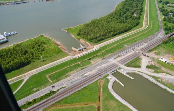
One of the better-known examples of this practice can be found at the Davis Pond Freshwater Diversion Project. Completed 11 years ago to move freshwater from the Mississippi River through Davis Pond in St. Charles Parish to a targeted area in Barataria Bay, it can output at a clip of 10,650 cubic feet per second, although it doesn’t operate at full capacity around the clock.
Sediment diversions, meanwhile, are used to stimulate marsh creation in open areas by channeling sediment — not just freshwater — into nearby wetlands to mirror the natural land-build process once provided by river flow.
While many in Louisiana might be more familiar with a process that involves something called a crevasse, or a gap cut into a levee, the state’s 50-year Master Plan also calls for utilizing a direct pipeline system along with dredging.
There’s also the conveyance channel method, which is being used in the West Bay Sediment Diversion Project south of Venice. New acres of land were created there after 2011’s high river stages, and it’s often cited as a successful example of sediment diversion.
This most-recent sediment cycle, though, may be the last for some time, as the federal funding source is coming to an end.
What’s being proposed
“The biggest misconception about the Master Plan is that it calls for more freshwater diversions of the Mississippi River. That is not so,” said Garret Graves, chairman of the Coastal Protection and Restoration Authority. “What the plan calls for are sediment diversions — just like Mother Nature used to build the entire state of Louisiana.”
So when proponents or opponents start talking about all of the new freshwater diversion projects being proposed, of which there are none, officials contend it’s problematic. Just like cases where folks try to compare the freshwater model to sediment diversion projects, they argue it’s like contrasting mud and water.
“Sediment from the upper Mississippi River system literally built our entire state,” Graves said. “Over thousands of years, dozens of sediment diversions naturally transported sediment to our coast causing Louisiana to grow by about three-fourths of a square mile per year.”
Opponents, however, do have what they consider to be serious beefs with freshwater diversion projects. The one at Davis Pond, as well as the Caernarvon Freshwater Diversion Project (which is a gap in the Mississippi River levee at the boundary between Plaquemines and St. Bernard parishes), killed nearby oyster beds, and fishermen are still complaining that redfish and trout have been chased away.
State officials say if the same projects were proposed today, they would push to turn them into sediment diversions to avoid these problems.
But opponents like Capt. George Ricks, owner of Get-Away Fishing Charters and president of the Save Louisiana Coalition, counter that the river water in the sediment diversion loads will do damage before any sediment offers benefits.
Ricks admitted that for every study he can offer bolstering his argument, the government can offer another disqualifying his stance. He said he doesn’t trust the government’s computer models and can only present the findings he’s confident in at this point in time.
“What the science is finding is the sediment is full of nitrates and fertilizers (runoff from Midwest farmlands), which creates a weaker root system,” Ricks said. “Plus, the river has one-fourth less sediment than it did prior to 1952.
“It will turn the marsh vegetation into a welfare plant, where it won’t have to work for the nutrients it needs.”
However, Dr. Bob Stewart, former director of the USGS Wetlands Center in Lafayette, said he was involved in one of the first sediment diversions in the Mississippi Delta that saw the U.S. Fish and Wildlife Service create a breach in one of the sub-deltas.
And he said it provided proof that the diversion model can work.
“Over the next year, it created marsh throughout that part, but we couldn’t afford to keep it open annually, so it closed off and subsidence became the dominant force,” Stewart said. “Soon all that was left was the natural levee that once surrounded that sub-delta.”
The experiment put into perspective the role time can play in such efforts, he said. It was also evidence that doing nothing can be more damaging than anything else, which some parties might be pushing for today, replacing construction with inactivity.
“In that time, sea level rise will have taken its toll on oysters, moving them farther inland,” Stewart said. “Increased storms due to climate change will likely be beating at New Orleans back door, without the protection of marsh.”
Stewart said public hearings and debate are critically important to the process, although both sides need to be looking toward the horizon.
“These folks that object live for the moment, as in the next 20 years,” he said, “but miss the big picture. It will likely take 20 years just to build a single, large diversion.”
Editor’s note: This is the second part in an ongoing series about the state’s Master Plan for coastal restoration, hurricane protection and flood control.
Log onto LouisianaSportsman.com/coastal-restoration to learn more about the fight to save the fragile Louisiana coastline.


")