$50 billion needed to fully implement comprehensive plan
According to Dr. E.L. Corthell, former president of the American Society of Civil Engineers, the breakdown of the Mississippi River Delta’s coastal wetlands is in part a debate of commercial use and flood control versus conservation. It’s about short-term benefits versus long-term benefits and finding a way to battle a rising sea and disappearing earth.
“It is a fact well known to people living in the delta of the Mississippi that large tracts of land were long ago abandoned in consequence of overflow by Gulf waters due to the sinking of the lands,” Corthell contended.
Thing is, Corthell wrote those words more than 115 years ago in the December 1897 issue of National Geographic magazine.
That’s all to say our ancestors faced the same challenges in terms of coastal restoration, hurricane protection and flood control that we do today.
Moreover, Corthell’s 1897 article forecasted the culprits, including worldwide sea-level rise, saltwater intrusion, industry initiatives and subsidence, which is the natural sinking of land.
What Corthell didn’t have access to — and what we currently do — is a 50-year blueprint that offers a solution to stemming the tide of land loss, which the U.S. Geologicial Survey estimates is equivalent to the size of a football field every hour, or 16 square miles ripped from Louisiana’s shoreline annually.
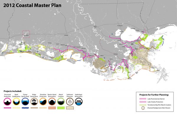
The blueprint is known as Louisiana’s Coastal Master Plan, and the state has a sophisticated government framework to support it that has been slowly taking form since the 2005 hurricane season.
Combining functions that were once spread over several departments is the Office of Coastal Protection and Restoration, which is under the executive branch. There’s also the Coastal Protection and Restoration Authority, or CPRA, which is the state’s guiding coastal board that approves money, crafts policy and prioritizes projects.
The master plan was approved by the CPRA and endorsed by the Louisiana Legislature last year. Developing that plan was an arduous process, said CPRA Chairman Garret Graves. It included an 80-member planning team, focus groups, 116 presentations, 10 community meetings and three public hearings attended by 1,350 people.
The end results are unmistakable, he said.
“Based on our calculations, we believe there is more work going on in terms of coastal restoration in Louisiana than all the other coastal states combined,” Graves said.
The master plan is carried out piecemeal every year through an annual plan, the latest of which was approved during the Legislature’s regular session. Annual plans operate under a fiscal year, rather than a calendar year, so the 2014 plan approved by lawmakers goes into effect July 1 and expire June 31, 2014.
While some lawmakers have asked questions about changing the annual plan, Graves said the document is set in stone, having gone through an extensive public comment period, and would require votes by the CPRA and Legislature — and probably necessitate another round of public hearings.
But by law, the annual plan does have to be legislatively updated every five years, meaning the next revisions will surface in 2017.
Inclusion of projects in the annual plan was competitive, and decisions were driven by two questions (queries that could also be found in Dr. Corthell’s 1897 National Geographic article):
• How well did the projects reduce flood risk?
• How well did the projects build new land or sustain the land we already have?
About 400 projects were included for evaluation in the master plan, of which the lion’s share (248 in all) are restoration projects. This category includes bank stabilizations, barrier island work, hydrologic restoration, marsh creation, sediment diversion, channel realignment, oyster reefs, ridge rehabs and shoreline defenses.
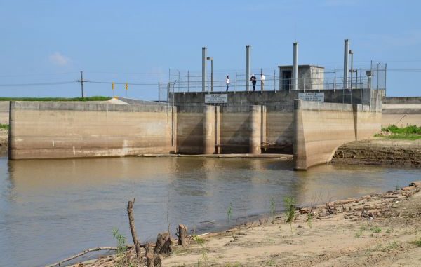
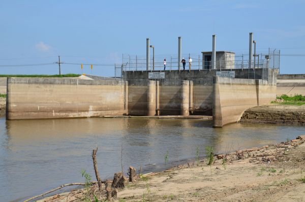
Another 149 projects are described as protection projects, such as levees, concrete walls, pumps, elevations, flood-proofing and voluntary land acquisitions.
To be certain, there’s much more to the plan. And it isn’t cheap, estimated to cost somewhere in the neighborhood of $50 billion between now and 2062. As for footing that bill, the efforts in the master plan will be and are being paid for through dozens of funding sources, mostly federal.
But it pales in comparison to coastal Louisiana suffering a 100-year flood event. When Graves makes presentations on the master plan, he has a slide showing a worse-case scenario, with 5 feet of floodwater as far north as Lake Charles and extending beyond Lake Pontchartrain.
Such an event would create damages ranging from $7.7 billion to $23.4 billion annually.
The majority of the money in the master plan is being dedicated to using up to 50 percent of the Mississippi River’s peak flow for sediment diversions, in addition to using water and sediment from the Atchafalaya River.
That’s also one of the more controversial parts of the master plan.
A group called the Save Louisiana Coalition has been formed to protest the diversions, and it consists of commercial fishermen, marina owners, charter captains, recreational anglers and restauranteurs.
Clint Guidry, a member who also serves as president of the Louisiana Shrimp Association, said he doesn’t find fault with any others areas of the master plan, but he fears the sediment and freshwater that would be pushed into fishing grounds.
“That’s just going to destroy us,” he said in a recent interview at the State Capitol.
Graves said comments from the public on the master plan have produced “broad-based support.” He has also said there are very few viable alternatives to sediment diversions, and a larger budget for the master plan would have presented more opportunities to explore different avenues.
As for the annual plan that will soon take effect, Graves said some of the money that resulted from the 2010 BP oil spill is being used to kick off the planning, engineering and design of the diversion projects, as well as to rehab areas that were damaged by the escaped crude.
In fiscal year 2014, the annual plan calls for $767 million in expenditures — of which 74 percent is going toward construction.
Some of the projects anticipated to begin or continue construction in the next fiscal year include:
• Bayou Dupont marsh and ridge creation in Jefferson Parish
• Bayou Lamoque floodgate removal in Plaquemines Parish
• Falgout Canal freshwater enhancement in Terrebonne Parish
• Freshwater Bayou bank stabilization and marsh creation in Vermilion Parish
• Grand Liard marsh and ridge restoration in Plaquemines Parish
• Jean Lafitte tidal protection in Jefferson Parish
• Lafitte area levee repairs in Jefferson Parish
• Mississippi River long-distance sediment pipeline in Jefferson, Lafourche and Plaquemines parishes
• Morgan City Industrial Road improvements
• Non-rock alternatives to shoreline protection in Iberia, Jefferson and Lafourche parishes
• Shell Island berms in Plaquemines Parish
• South Lake Lery shoreline and marsh restoration in Plaquemines Parish
• St. Charles West Bank hurricane protection levee
It’s a far cry from the “large tracts of land (that) were long ago abandoned,” as described 115 years ago by Dr. E.L. Corthell. His National Geographic article of yesteryear was filled with doom and gloom in terms of what the future might look like for Louisiana’s coast.
But it also suggested that there would some day be solutions.
The one document, however, that Corthell was unable to review was the state’s master plan, which could have offered him 190 pages of heightened hope, despite its more controversial aspects.
“It is a plan worth following,” Graves said, “as it demonstrates scientifically that we can greatly reduce the expected risk of damage to our coastal communities from storms, as well as begin to address the land loss that has been plaguing Louisiana.”
It’s a promise that Corthell, could he have heard or read it, would have probably liked.


