Looking to have success on marsh ducks in the mid-day hours? Then head to the salt marsh, where ducks go to spend some time on the roost.
Dear Capt. Paul:
Could I get the coordinates to the Lump from Grand Isle’s Barataria Pass? If so, about how far is it from the jetty there?
Stephen Grigsby
Capt. Paul’s response:
By “the Lump,” I assume you mean the Midnight Lump, and will provide you with what information I have on its location.
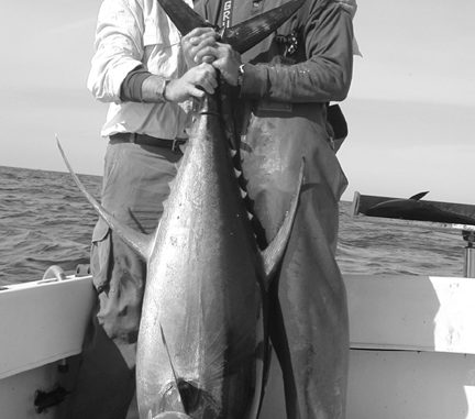
An area in the Gulf of Mexico named Sackett Bank is commonly called the “Midnight Lump.” It is a draw for tuna and wahoo during certain times of the year. The Midnight Lump has become very popular in the last decade; sometimes there are more than 100 boats a day in the active part of the season.
The location is about 20.14 miles from Southwest Pass of the Mississippi River at a bearing of 202 degrees.
That makes it about 49.64 miles at a bearing of 152 degrees from the red No. 12 marker in Barataria Pass, which is at a point in the channel that is between Grand Isle and Grand Terre Island, and about 48.8 miles at 142 degrees from the center of Caminada Pass at the western tip of Grand Isle.
NOAA chart No. 11316A-leased blocks, Mississippi River to Galveston shows the Lump as well as the entrance to Southwest Pass and Barataria Pass at Grand Isle. I suggest you purchase that chart.
The approximate center of the Lump is at or about N28 38.122 x W89 33.249.
Caution should be used as this position is at least 20 miles offshore from the Venice launch and the boater must navigate the Mississippi River, and it is about 50 miles from Grand Isle at Barataria Pass. The Grand Isle course will have to be made in open water of the Gulf, and the Southwest Pass approach has another 30 miles of running in the busiest part of the Mississippi River to reach Venice.
Neither route is recommended for an inexperienced boater or a boat that is not seaworthy for this type of trip. If you intend to make such a trip, be sure to leave a float plan with a friend or relative who will remain on shore, and be certain to have a reliable VHF Marine radio.
Check out Chris Holmes’ article in the February issue of Louisiana Sportsman (p. 55), “Catamaran sinks at Midnight Lump.”
Either way you will experience a trip that will be at least 100 miles. By using the 1/3-1/3-1/3 fuel principle, you will need enough fuel for at least a 150-to 160-mile trip.
You will also need a deepwater depth finder to actually find and “see” the exact Lump location. The seabed rises from about 60 fathoms to 33 fathoms at the Lump. Picture a series of truncated cones rising from the seabed. Gulf currents push water over the top of these formations, causing smaller baitfish to be pushed against and over the Lump. Amberjack, tuna, marlin, snapper, grouper and wahoo gather there to eat.
Usually fishing one side of the Lump is better than the other, depending on the currents.
Bring plenty of anchor line, as you will need every foot of it. Most anglers suggest you use a minimum of 600 feet with anywhere from 10 to 30 feet of chain. The chain will greatly enhance your anchor’s ability to set. A medium-sized vessel (28 to 35 feet) should use at least a 24-pound anchor.
Some captains suggest an anchor point on the Lump at about 250 feet deep.
All positions are stated as ddd, mm.mmm, and were determined using WGS 84 Datum. All bearings are stated in magnetic degrees, and are shown as statute miles.
Dear Capt. Paul:
I just received my Garmin GPSMAP 76cs with America’s Autoroute Basemap, Mapsource City Select, Mapsource Trip and Waypoint Manager software.
I hunt and fish in the interior marshes of St. Bernard and Plaquemines parishes, and areas around Picayune and Poplarville, Miss.
The maps with the City Select software show some detail in the interior marshes, but I would like more detailed maps. What cartography software do you recommend for this unit.
Thanks,
MVoss
Capt. Paul’s response:
You have one of the finest units that Garmin makes. The GPSMAP 76cs handheld is their flagship model. I’m sure you will get many hours of use out of the unit.
The MapSource CitySelect mapping software shows cities, roads and streets. It is designed to allow you to map routes that follow these existing roadways when using the unit in a land vehicle. Most GPS units can only display a route as a point-to-point route. The GPSMAP 76cs can do routes either way.
In the menu under setup and routes, you can select the option of “follow the road” (autorouting) or “point-to-point” routing.
The “follow the road” routing makes the GPSMAP 76cs comparable to those high-priced GPS navigation systems you see in the upper-end cars and SUVs, but it also has the ability to operate strictly as a handheld unit in your boat or backpack.
In addition, the unit when loaded with other Garmin MapSource software, can provide you with maps of the entire United States as in their United States topo and offshore with their BlueCarts.
I suggest you consider the Garmin MapSource US Topo mapping software, which would give you a first-class unit with mapping software that could accommodate your type of fishing and traveling as it contains MapSource topographical maps of the entire United States including Alaska and Hawaii.
You can check out the MapSource US Topo at www.garmin.com, and even view an area on their viewer. Or better yet, you should visit a Garmin dealer and ask to view the US topo software in a Garmin unit. That way you can determine for yourself if the additional money is worth it. Remember that the Garmin MapSource software is the only one that will work in the GPSMAP 76cs.
Once you have the software, it will load into your existing MapSource program, offering you a choice of viewing the CitySelect or Topo version of maps you may want to load into your GPS unit. The unit can have one section of maps for a trip to another city, and still have topo maps for the cities and marshes that you frequent.
The combination of the GPS MAP 76cs and the different types of mapping software allows you to have one of the most versatile systems on the market.
Got a GPS question for Capt. Paul? You can ask it at www.lasmag.com.


