

If you are interested in line-breaking tuna and other large species in the Gulf of Mexico, then you should at least try the Midnight Lump.
No, it is not a lump on your head you got from a frying pan when coming home very late one night; it is a favorite big-fish area within 21 miles from the mouth of the Mississippi River at Southwest Pass.
The Midnight Lump is a draw for wahoo and tuna, and has really become a very popular location in the last decade, mainly because of the Global Positioning System that allows anglers to accurately find the underwater feature.
The site looks like just open water, but 200 plus feet beneath the surface is a very distinct subsurface natural feature. During the “run” at the Lump, you may find more than 100 boats a day anchored or trying to anchor at the site.
The Midnight Lump is one of the most-prolific locations for all kinds of big fish in the near shore Gulf of Mexico. The location’s official name is The Sackett Bank, and it’s shown on most official NOAA Marine charts.
The Sackett Bank is located just north of the Outer Continental Shelf in Block 148 of the West Delta Leased Area, Southern Addition. A portion of the feature is actually in the northern part of the Leased Block 316 of the Mississippi Canyon.
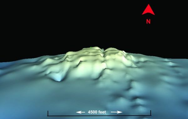
The nearly circular 2.9-square-mile area is an uprising of the seabead made of carbonate sediments, sand, drowned coral reefs, algal nodules, rock ledges and debris, which now includes many boat anchors. The relatively flat, broad crest is at a depth of about 206 feet. The base extends to a depth of about 360 feet, slanting away from the crest.
Picture a series of truncated cones rising from the seabed. The constant Gulf currents push water around and over the top of these formations. This causes the smaller bait fish to be pushed against and over the lumps at the site. You’ll usually find amberjack, tuna, marlin, snapper, grouper and wahoo gathered there to eat.
Fishing on one side of the Lump is normally better than the other, depending on the prevailing currents. These currents will determine which side of the Lump is the better side to fish; however, some anglers have their special spot to fish regardless of the water flow.
You will find many different coordinate positions for the Lump, which is to expected of such a large area. However, I believe that the approximate center of the area is at or about 28° 38.250’ N. Lat ~ 89° 33.410’ W. Long.
Depending on other boats and the conditions, you should adjust your actual position using your depth finder.
You will also need a deep saltwater depth finder to actually find and “see” the exact location. It is fascinating to see the lump as an image on a printing sonar unit or as shown in the accompanied photograph. If your unit allows, save the GPS track and the sonar image for later review.
Once the fish start biting, just mark your own favorite spot on the lump with your GPS unit, and it will be money in the bank for future visits.
The location is about 23 miles from the Southwest Pass of the Mississippi River near the lighthouse (near land’s end by the end of the east jetty) at a bearing of 202 degrees magnetic. That makes it about 19.4 miles at a bearing of 203 degrees magnetic from the Green No. 1 Going buoy in the lower starting point of the official Southwest Marine channel.
Even in this digital world, I always recommend that anglers have a paper chart for navigation purposes. NOAA Charts 1116, Leased Blocks MS River to Galveston shows all of the leased blocks in the covered area, and Chart Nos. 11366 MS River and Approaches, 11340 MS River to Galveston, and 11361 MS River Delta are very useful in aiding the trip from Venice to the Sackett Bank. These charts can be found at any official print-on-demand marine chart supplier, such as Baker Lyman on Veterans Boulevard in Metairie or in marine stores such as West Marine located throughout the area or even direct from the NOAA Office of Coast Survey at www.nauticalcharts.noaa.gov/staff/charts.htm.
All boaters should use caution when navigating to and fishing this location, as navigating the Mississippi River to the Southwest Pass — which is about 30 miles from Venice — makes it at least a 50-mile one-way trip. Remember that this part of the Mississippi River is the busiest part of the water way, and you may have to give way to some of the larger ocean-going vessels. Your total trip from Venice at the Jump will be at least 100 miles. By using the 1/3-1/3-1/3 fuel principle, you will need enough fuel for at least a 150- to 160-mile trip. Can your rig tote enough fuel?
The route is NOT recommended for inexperienced boaters or boats that are not seaworthy for this type of trip. Several boats sank in the area, and the charts for the Lump actually show a sunken boat almost on top of the feature. A 2005 story in Louisiana Sportsman titled “Catamaran Sinks at Midnight Lump” by Chris Holmes details such a sinking.
If you intend to make such a trip, be sure to leave a float plan with a friend or relative who will remain onshore, and be certain to have a reliable VHF Marine radio and a satellite phone, as cell phones may not be reliable that far from the shore.
Please bring all required and other safety equipment necessary for such a trip.
When fishing the area, bring plenty of anchor line, as you will need every foot of it. Most experienced Lump fishers suggest a minimum of 600 feet of anchor line, with anywhere from 10 to 30 feet of chain. The chain will greatly enhance your anchor’s ability to set.
Your anchor size will vary greatly, but a medium-sized vessel (28 to 35 feet) should use at least a 24- to 30-pound model. Some captains suggest an anchor point on the Lump at about 250 feet deep; it pays to have marked your line at different lengths to determine how much line you have out. Such a line marked at 100, 150, 200, 250, 300, 350, 400, 450, 500 and 550 feet will be an aid in determining how much line you have out. And, of course you will need someone with a strong back or an anchor windless.
But, more important, bring all of your seamanship, courtesy and a lot of patience, as you will be competing for an anchorage and your fishing lines might cross with other anglers in the same area. Be prepared to sacrifice your terminal tackle because of the Lump itself and because of other anglers.
The normal big-fish baits are productive, but sometimes a straight line with a heavy sinker and bait about 10 feet above the sinker will also work.
All positions are stated as ddd, mm.mmm and were determined using WGS 84 Datum. All bearings are stated in Magnetic degrees and are shown as statute miles. You should set your GPS unit accordingly, especially the Datum to accurately locate the lump. An incorrect datum may cause a deviation of over ½ mile or more.