Why would the driver of a car spend hundreds of dollars for a GPS navigation device just to do something that nearly anybody can do with a $10 road atlas? After using a Lowrance iWAY 500c for a couple of years, I think I know.
I was recently reminded that these units are a heck of a lot more than just electronic roadmaps. I flew into Houston International Airport on a rainy evening and had to drive across town in a rental car. I hadn’t been to Houston in years, partly because I’d rather drive a hundred miles out of my way than have to drive through it.
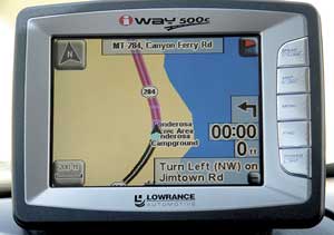
I loaded my luggage in the rented car, and hooked up the old iWAY unit on the dash. This requires sticking the suction cup base to the windshield, adjusting the bracket angle and plugging the power cord into the cigarette lighter receptacle. The power plug has a speaker and volume control built into it for delivering turn-by-turn voice prompts that parallel visual prompts on the screen. I had entered the street addresses of all my Houston-area destinations into the unit’s address book before I left home.
I drove out of the covered parking garage at the airport and parked under open sky. The unit took about a minute to fix its position and let me know it was ready to go. I pressed the “Find” button and then the touch-screen key marked “Address Book.” I scrolled down to my first destination, touched it, and then selected the “Go To” command. The unit took less than a minute to generate a route. It told me to turn left out of the parking lot and then directed me to the address through the darkness and rain. I didn’t have to dig out my reading glasses to look at a map or follow written directions, and I didn’t have to touch another button, all dangerous things to do while driving.
I encountered only one hiccup in two days of driving, and it was because I’d used the unit for almost three years without having its map updated. It showed a hard right turn coming up in the middle of a highway overpass because a new freeway now covers the old intersection in its memory. The unit’s on-screen turn preview feature told me my turn was two-tenths of a mile ahead, and I could see an overpass about that far in front of me. I exited the freeway, and as I stopped at the intersection a voice prompt and a glance at the screen assured me I was right on course.
An automotive GPS unit helps even when it isn’t navigating. It tracks your position as you travel and shows you the road ahead. You can see which way the road will turn and spot upcoming side roads that might generate cross traffic. It can also keep you clear of dead ends or other situations that require you to back out when towing a boat or camper.
Most units contain information about roadside services, and you can click on an exit or intersection and see a list of the points of interest nearby. Knowing whether an exit offers gas, food or lodging helps you decide to take it or go on to the next one.
The iWAY 500c also stores MP3 music that you can play through your vehicle’s stereo system. I’m now testing the iWAY 500’s replacement, the iWAY 600c. It contains some 5.5 million points of interest along with all of Lowrance’s marine cartography. The 600c is waterproof and can be moved from your tow vehicle to your boat. It also stores MP3 music and has a built-in FM transmitter that can broadcast tunes directly to your vehicle or boat stereo system over a locally empty FM station.
Automotive GPS units are made by a variety of companies, and each generation of products offers more than the last. They are worth a close look if you spend much time on the road.