Blind datum

Use the correct one, or miss your mark

Captain Paul Titus

February 01, 2012 at 7:00 am  | Mobile Reader | Pring this storyPrint 

This visual shows the difference between the two positions using different datum settings in the GPS unit. The aerial images are photo maps of a park in Colorado Springs, Colo.
Dear Capt. Paul:

We recently conducted a navigation demonstration using a Rockwell PLGR II (military grade).

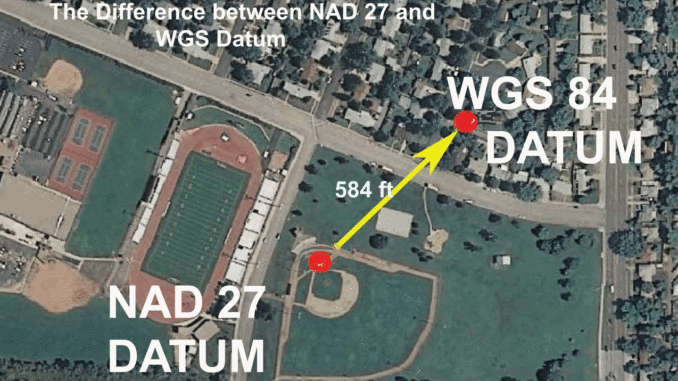
The navigation course consisted of 34 known civil surveyed points. Using the data that was provided and analyzing our data, we concluded that after proper conversions (the same software they used), we were 2 to 38 feet off east to west and 600 feet off to the north for most of the positions. Why the variation and can you explain the 600 feet?

Sammy,
Colorado Springs, CO

Capt. Paul’s response:

The Rockwell/Collins GPS unit PLGR II is one of a series of GPS units offered for military use. There are several PLGR units available, so I am not sure that the unit you are using as a demo has the ability to receive the civilian (code C/A) or only the military versions (Code P or P+AS encrypted) of GPS transmissions. The baseline unit was made from 1993 to 2005, and has the ability to receive the restricted military signals. Military-version GPS units generally offer a more stable and accurate position locator, usually assumed to be under 6 feet of accuracy with the code "P" and much less with the P+AS version. The actual accuracy is classified.

Newer civilian units usually can obtain an accuracy of under 9 feet with the added WAAS differential system incorporated into the receiver. My Garmin GPS 62 MAP with the WAAS activated consistently delivers a 9-foot or less accuracy reading.

With either version of the transmitting GPS signals, I would assume that the unit was operating properly and should be capable of providing an accurate position. This will lead me to assume that the 600 foot error is caused by another factor.

I am not sure what "conversions" you made to obtain your readings. I suspect that the conversions you are describing are converting MRGS or UTM/UPS to latitude and longitude or the reverse. I will assume that your "conversions" are correct, but by your description of the error factors, it sounds like the position readings of the GPS receiver and the known civilian survey markers were plotted or fixed using different horizontal datum.

Locate the map on which the surveyed points are marked and the details in the civilian plotted positions. Note the datum that was used to plot the location (horizontal datum). I believe that the most if not all USGS topographical maps in the Colorado area were configured using North American datum of 27 (NAD 27). Some Colorado topo maps were updated in 1981 using the more modern NAD 83 datum. If the surveyed points are older than 1983, they were probably surveyed using the NAD 27 datum. The United States National Geodetic Survey (www.ngs.noaa.gov/cgi-bin/datasheet.prl) has a listing of all benchmark positions in their files of official survey data sheets. Each data sheet has a very precise plotted position of the survey marker and lists the datum that was used to plot the position. Check out the "Civil Surveyed" points to see if they are in fact a USGS-plotted benchmark. If so, then you can simply check the datum in your GPS unit to see if that was the figure you obtained when at that benchmark.

The PLGR unit has the ability to use 50 preset datum and two user-defined datum. As a suggestion, check the datum in the setup program or datum screen page of the GPS unit. If it is set to a different datum than the civil mapped positions, change it to match the civil datum.

By that, I mean convert the surveyed point to an available datum in the GPS unit by using the U.S. Army Corps of Engineers conversion program that it available for downloading at crunch.tec.army.mil/software/corpscon/corpscon.html.

The site allows a conversion of a variety of datum and position formats. It is worth the look and even saving it in your computer for future use.

If the unit cannot be reprogrammed to the same datum as the civilian surveyed point, convert the civilian surveyed point to a available datum in the GPS unit. Either way the position format figures must agree in a common datum for the values on the map and in the GPS unit to be the same. In the conversion, try NAD 27 CONUS (North American datum 1927, Continental U.S.)

Unless otherwise specified, all positions are stated as degrees, minutes and ten thousandths of minutes (DDD,MM.mmmm), and were determined using WGS 84 datum. All bearings and courses are stated in magnetic degrees.

Captain Paul


View other articles written Captain Paul Titus


Reports / Forum
Breton Sound Bullred Fishkill.  This report contains photos   This report contains a video
May 17 at 12:12 pm | 5637 Views | 16 Comments
Trestles 5/15/13  This report contains photos  
May 16 at 8:32 pm | 3364 Views | 7 Comments
Father-Daughter team none stop action out of Shell Beach.  This report contains photos  
May 15 at 10:03 pm | 2789 Views | 2 Comments
Sick Trout Action! 5-14-13  This report contains photos  
May 14 at 10:10 pm | 1969 Views | 1 Comments
PAC monster slam!!!!  This report contains photos  
May 17 at 2:06 pm | 1945 Views | 6 Comments
Stuff happens  This report contains photos  
Yesterday at 10:39 am | 1945 Views | 4 Comments
Best Area to Learn for Beginner 
May 16 at 2:02 pm | 1796 Views | 20 Comments
Tuna time!  This report contains photos  
May 16 at 3:18 pm | 1723 Views | 3 Comments
Venice vs Grand Isle  This report contains photos  
May 17 at 11:37 am | 1466 Views | 3 Comments
What's the spillway looking like? 
May 15 at 7:47 pm | 1457 Views | 6 Comments
Trestle Report 
May 16 at 12:58 am | 1423 Views | 2 Comments
5/18/13 RIGOLETS  This report contains photos  
Yesterday at 7:30 am | 1410 Views | 2 Comments
New Boat - Ready to Fish!  This report contains photos  
May 17 at 9:26 am | 1319 Views | 4 Comments
lake Pontchartrain 
May 15 at 10:34 pm | 1292 Views | 8 Comments
trolling motor on a budget  This report contains photos  
May 18 at 10:50 am | 1089 Views | 4 Comments
SPECK-tacular!!! 5-15-13  This report contains photos  
May 15 at 5:22 pm | 1079 Views | 0 Comments
REEL LIFE FISHING  This report contains photos  
May 15 at 8:34 am | 1053 Views | 0 Comments
Ski fish  This report contains photos  
May 17 at 11:47 am | 1029 Views | 8 Comments
Fouchon 5/18  This report contains photos  
May 18 at 12:56 pm | 1009 Views | 1 Comments
Windy day Trout 5-19-13  This report contains photos  
Yesterday at 5:36 pm | 937 Views | 1 Comments
Post | Reports | Forum
Best Area to Learn for Beginner 
May 16 at 2:02 pm | 1796 Views | 20 Comments
Breton Sound Bullred Fishkill.  This report contains photos   This report contains a video
May 17 at 12:12 pm | 5637 Views | 16 Comments
Need tips on best kayak spots 
May 14 at 11:12 pm | 775 Views | 9 Comments
Fourchon Beach 
May 18 at 10:36 pm | 716 Views | 9 Comments
Pete's Landing 
May 15 at 7:51 am | 572 Views | 8 Comments
lake Pontchartrain 
May 15 at 10:34 pm | 1292 Views | 8 Comments
How to get my burn permit? 
May 16 at 10:04 pm | 293 Views | 8 Comments
Ski fish  This report contains photos  
May 17 at 11:47 am | 1029 Views | 8 Comments
CCA REEF 
May 16 at 9:51 am | 395 Views | 7 Comments
Trestles 5/15/13  This report contains photos  
May 16 at 8:32 pm | 3364 Views | 7 Comments
dispute of boiling crawfish 
20 hours ago | 485 Views | 7 Comments
What's the spillway looking like? 
May 15 at 7:47 pm | 1457 Views | 6 Comments
PAC monster slam!!!!  This report contains photos  
May 17 at 2:06 pm | 1945 Views | 6 Comments
Sorrel 5/18 
May 18 at 5:16 pm | 434 Views | 5 Comments
2 stroke or 4 
May 15 at 2:07 pm | 370 Views | 4 Comments
Hopedale 
May 15 at 9:23 am | 510 Views | 4 Comments
'She Met Her Waterloo' 
May 15 at 11:06 am | 335 Views | 4 Comments
slower day  This report contains photos  
May 15 at 1:37 pm | 445 Views | 4 Comments
Grand Isle/Elmers Island 
May 16 at 8:59 am | 665 Views | 4 Comments
New Boat - Ready to Fish!  This report contains photos  
May 17 at 9:26 am | 1319 Views | 4 Comments
Post | Reports | Forum
Grand isle visit 
21 minutes ago | 12 Views | 0 Comments
Summer Time Bite Is On!  This report contains photos  
35 minutes ago | 68 Views | 0 Comments
Can you recomend GPS 
2 hours ago | 27 Views | 0 Comments
Fishing bayou bienvenue 
3 hours ago | 66 Views | 1 Comments
Where did my post go? 
3 hours ago | 160 Views | 4 Comments
Grand Isle bridge 
3 hours ago | 78 Views | 0 Comments
Wind? 
3 hours ago | 36 Views | 0 Comments
Hunting club help 
3 hours ago | 169 Views | 0 Comments
Looking for a good spot this evening 
4 hours ago | 75 Views | 1 Comments
Yak trip to Grand Isle 
4 hours ago | 53 Views | 0 Comments
No Friends?  This report contains photos  
5 hours ago | 300 Views | 0 Comments
Summer on Toledo Bend  This report contains photos  
10 hours ago | 280 Views | 0 Comments
Amberjack 
14 hours ago | 85 Views | 1 Comments
GoDevil Hull  This report contains photos  
14 hours ago | 180 Views | 2 Comments
GoDevil Hull 
14 hours ago | 39 Views | 0 Comments
Cow island?? 
14 hours ago | 115 Views | 0 Comments
Charter Needed for June 14th 
15 hours ago | 56 Views | 0 Comments
Camper spot in tensas 
15 hours ago | 45 Views | 0 Comments
Sharks 
15 hours ago | 89 Views | 0 Comments
St Charles Parish West Bank Boat Launch 
15 hours ago | 44 Views | 0 Comments
Post | Reports | Forum