


This convenient area is too easy and fish-filled to pass up in November.
Four months ago, I was wondering if the waters around Lafitte would ever be the same. As the oil from the Deepwater Horizon disaster crept through the passes down to the east of Grand Isle, it looked like one of the most fertile estuaries in the world had finally met its match.
However, if the early part of this fall is any indication, the only thing folks around Lafitte are going to have to worry about this winter is whether they’re going to fish Little Lake, Turtle Bay, Bayou Perot, Bayou Rigolets or The Pen.
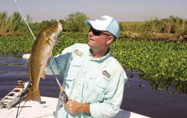
Capt. Scott Poche has spent more time on the water helping to clean oil out of the marshes farther south most of the summer and early fall, but he was gracious enough to give me a first-hand look at just how clean the water is from Bayou Perot to Little Lake and down into Turtle Bay a few weeks ago.
My flummoxed descriptions ranged from gin clear to “looks like a swimming pool out here,” and we saw three or four times more redfish following the ones we were fighting than we wound up putting in the box, which was 10.
Do the math, and you can see that the combination of shallow, clean water and cruising redfish adds up to some awesome days on the water this autumn as long as you’re not expecting many trout.
“I imagine we’re going to have very few trout because of the salinity levels being so low,” Poche predicted. “We’ve had so much fresh water pushing through here that the water hasn’t been salty enough for them. Things could change, but it looks like redfish are going to be the main draw.”
There’s surely not anything wrong with that, but there could be something wrong if the wind blows hard from the north. Lafitte is notorious for getting messed up after a strong cold front, and that’s why Poche pointed out the deeper bays like Bayou Perot, Little Lake and Turtle Bay.
“In November, we’ve got the likelihood of the water getting pushed out,” he said. “If it does get blown out, all you’ve got to do in these three spots is move out deeper where you can still fish decent water. Leaving from Lafitte Harbor (Marina), you can make a little run of these 10 spots no matter what the weather or water is doing.”
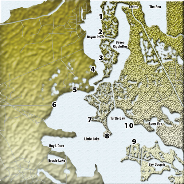
• No. 1: Bayou Perot North Points
N29 39’05” x W90 08’45”
Heading down the eastern shoreline of Bayou Perot, this is the first of three similar spots where Poche routinely finds pods of cruising redfish not so subtly sneaking down the bank. This spot in particular has a couple pockets inside the marsh and several points that stick out into the open water of Bayou Perot.
“I like to key on the points with a falling tide and move into the pockets when the water is rising,” Poche said. “When the water is pulling out, reds stack on the points to eat all the minnows and crabs that wash around the points. When it’s rising, they move back to feed around the grass.”
When the tide is falling, the water will run north to south, so it’s a good idea to get on the downcurrent side of the points, the south side, and cast north into the current. However, Poche says that the points are so small that anglers could set up off the points in such a away as to cover both sides of the points.
“Typically, they’re on the downcurrent sides of the points where the eddies are,” Poche added, “but I’ve seen them pressed up against the upcurrent side, too. As for the pockets, they’re about 1 1/2 feet deep, so you can get in them except when the tide is falling; then they get too shallow.”
• No. 2: Bernstein Cut
N29 38’05” x W90 08’57”
Moving a few hundred yards to the south of Bayou Perot’s eastern shoreline, Poche stops at the mouth of Bernstein Cut. There’s a little island here that is the key to this spot, and Poche specifically targets the points to the east or west depending on where the combination of tide and land congregates the bait.
“The tide hits this island and runs off both sides, and the reds just kind of run back and forth depending on where the bait is,” Poche explained. “Any tide is a good tide, so the only bad day to fish here would be when we’ve got a slack tide. The only difference between an incoming and a falling tide is fishing a different side of the island.”
If the salinity is high enough to support speckled trout, Poche says the current line coming off of either point will stack them up out as far as 40 to 50 yards off the island.
However, the reds typically stack up against the shoreline.
“This cut goes from Bayou Perot to Bayou Rigolets, and you can pass through it,” Poche said. “It can be good, too, when there is tide moving through it. And you can also fish the smaller bayous that come out of the duck ponds around here. Fish up in them if you can, but stick with the mouths if the water’s too shallow.”
• No. 3: Bayou Perot South Points
N29 36’17” x W90 08’50”
There is nothing dramatically different about the last of Poche’s spots along the eastern shore of Bayou Perot. This is a jagged shoreline with lots of points and coves. In fact, Poche admitted there really isn’t a bad spot along this entire shoreline; it’s just that these have been three of his most productive spots in the past.
“Between Bayou Perot and Bayou Rigolets is a thin strip of land that is just full of duck ponds that have cuts that come out,” Poche said. “This is just one of the spots where you have a great combination of backwater ponds that dump into Perot and points that tend to congregate reds a little better than some other spots along this shoreline.”
Poche decides which of these three spots to fish based on the presence of bait. It’s easy for him to jump around these three spots until he finds the magic combination. Then he makes several passes through the productive areas in an effort to maximize the hotspots.
“If you pick up three or four reds in a 200-yard stretch, idle away from the shoreline, go back up and fish that same spot again,” Poche suggested. “Fish all three of these spots with a combination of gold spoons, black/chartreuse, purple/white or purple/chartreuse H&H Cocahoes tightlined or under a cork, and 3-inch molting or new penny Gulp Shrimp under a cork.”
• No. 4: Bayou Perot Wall
N29 35’35” x W90 09’48”
The obvious spot to fish at spot four is the cement wall that was put in for coastal restoration in an effort to control erosion along the western side of Bayou Perot. This wall has a few openings that concentrate current when the tide falls, and all the bait in the marsh behind the wall drains out with the water.
“You can anchor out in front of these openings and throw into the cuts to catch redfish,” said Poche. “Besides redfish, these holes also attract a lot of black drum, sheepshead and flounder. The wall kind of created a little duck pond behind it, and all that water falls out with the tide.”
Poche likes to throw something smelly in these cuts, and he recommended fishing with the Gulp baits or shrimp under a cork right in the middle of the gaps in the wall. The best thing to do is cast beyond the wall and allow the current to pull your cork out with it.
“Because of this wall, the redfish have a straight line that they follow as they cruise looking for bait,” Poche added. “Since there aren’t any pockets that they can get into, and it’s a little deeper water, you can troll it like you would the shoreline while throwing spinnerbaits or the black/chartreuse H&H Cocahoes.”
• No. 5: Little Lake North
N29 34’20” x W90 11’06”
Although it’s probably of the most heavily pressured shorelines around Lafitte, the north shore of Little Lake continues to give up limits of redfish to those willing to put up with some boats around.
There’s lots of room, though, and Poche pointed out that the entire stretch from Little Temple Cut all the way to the Cloverly Canal is good.
“You can pull up to those shorelines right where you come out of the Little Temple Cut,” Poche said. “This is a long, shallow shoreline that is full of little cuts and coves. It’s a good shore to fish in November because it is protected from any strong north winds.”
Poche says you can put your trolling motor down and fish this entire shoreline, or you could just jump around from spot to spot depending on the presence of baitfish or visible signs of cruising redfish, which roam back and forth this entire bank.
“Sometimes there’ll only be one or two fish,” he said, “but sometimes there’ll be nine or 10 all in the same school. You can spot them coming because they throw deeper and more pronounced wakes than mullet. And if you’re fishing a school and they pass you, chase them down by cranking up and getting back in front of them.”
• No. 6: Cloverly Canal
N29 33’20” x W90 12’51”
The mouth of Cloverly Canal is an area protected by lots of big rocks, and the only way water can move between Cloverly and Little Lake is a cut right in the middle of these rocks.
This cut attracts a bunch of redfish, black drum, sheepshead and flounder. Poche says you could even catch an occasional trout around here.
“The cut is pretty deep — 6 to 7 feet in its mouth,” Poche said. “And the rocks run all the way across. Outside the cut, the water runs about 2 to 3 feet deep. You can catch fish from one into the other, but the cut is the spot you want to fish.”
Poche says the cut is good on a rising and falling tide, but he believes that sitting on the outside during a falling tide by far offers the best bite. Market shrimp, live cocahoes and artificials all work in the cut. He added that you could even go through the cut and throw some spinnerbaits in the canal with the added bonus of a few bass.
“About the only other thing you could do here is run the outside of the rocks with some kind of shallow-diving crankbait that looks like a minnow,” Poche said. “Anything with a black back or a gold back will work if you throw them parallel to the rocks.”
• No. 7: Mouth of Texaco Canals
N29 32’13” x W90 09’52”
The Texaco Canals are well known for giving up lots of redfish, but a lot of the water in this maze of canals and ponds gets too shallow to fish. That’s why Poche recommended fishing this spot where fish can make their exit into deeper waters.
“This is the east shoreline of Little Lake, and you can tell you’re in the right spot because you can see the tank batteries in the distance,” Poche said. “This entire mouth of the Texaco Canals all the way back into Turtle Bay is a good area.”
Poche pointed out that there are some stumps and a shell reef that comes out off the points. When the tide falls, it runs through here and heads south right over these reefs. They’re on the shallow side at about a foot and a half, but they can stack up with fish.
“You can catch trout here if the salinity is right,” Poche said. “And there are a ton of reds. They like these reefs too, but you’ll mainly catch trout if they’re in the bay. You can fish the Texaco Canals if you can get around in them, but you’ll probably do best back out here.”
• No. 8: The Y
N29 31’17” x W90 8’42”
Locally known as the Y, this is a small piece of island that separates Turtle Bay from Little Lake. It’s easily identifiable by all the white shells that surround it, and all these shell bars hold lots of bait and redfish.
“It’s not unusual to see big schools of reds swimming along these shells,” Poche said. “It’s good for trout depending on the salinity, but I like to throw spoons, spinners and H&H Cocahoes all the way around the island.”
The north side of this island features a shell bed that extends about 150 yards into the bay, and it tops out about a foot and a half below the surface. Redfish cruise this reef when the tide is moving across its top.
“You’ll also get a lot of sheepshead around here because of the rocks,” Poche added. “And there’s no difference here in where you catch the redfish and trout because they generally stick around the same places. If you’re specifically after trout, though, fish a white or chartreuse H&H beetle about 18 to 24 inches under a cork.”
• No. 9: Turtle Bay South
N29 30’20” x W90 6’23”
This is the south end of Turtle Bay, and it is lined with shallow flats with a little grass on them from all the freshwater diversions. The grass and flats combination concentrates bait on the shorelines, but this is one of the few spots listed that won’t be so good with a north wind.
“Start at the red signs and work east or west,” Poche said. “You can fish either way blind-casting a spinnerbait or spoon if it’s a little muddy. If it’s clear, stick with sight casting to the reds you spot cruising down the bank.”
Because it’s so shallow up against the bank, Poche recommends scanning the water from the bank out to about 100 yards as the redfish could be schooled up anywhere in between.
“Look a lot out to open water,” Poche said. “Keep your eye on the shore, but the reds like to cruise closer to the deeper water here where these flats fall off. And if it’s salty enough, try the trout farther out with the beetle or Cocahoe under a cork.”
• No. 10: Sweetwater Point
N29 31’53” x W90 6’28”
This is one of the points outside Sweetwater on the east side of Turtle Bay. Sweetwater is a canal that comes out of the marsh from some of the duck leases. When the water pulls out of the marsh and runs across this point, Poche says the reds stack up to take advantage of the situation.
“This point has some rocks protecting a pipeline here,” he said. “And there is a shell reef that comes off the point. When the current comes out of the canal, you can see the water swirling around the point and over the reef.”
If you’re after redfish, fish close to the visible rocks with market shrimp or Gulp plastics under a cork and plastic Cocahoes tightlined on the bottom.
If you’re going with the stinky stuff, you’re more likely to hook some black drum and sheepshead.
“As for trout, this is a very good spot for fall fishing,” Poche said. “Get out away from the point and fish the beetles under a cork. Watch for the current lines washing over the reef and get a bait in there. That is, assuming the salinity is right for the trout.”
Contact Capt. Scott Poche at 504-915-0392.
")

