Now is the time to get in the woods with your GPS. Now is the time to hit the woods and establish your GPS waypoints and trails for your stands, blinds and favorite hunting locations.
Yes I know that it is hot out there, but a little preseason scouting with you marking your stands and routes to them will be an invaluable asset when the actual season begins. So douse yourself with bug repellant, tote along some extra water, a comfortable hat, a machete, a decent map of the area and, of course, your GPS receiver, and hit the trails.
Your trip can actually serve several purposes if you bring your GPS unit with you.
One benefit of an early trip is that you may be able to use an ATV, motor boat or even a road vehicle on some of the access roads or foot trails. The ATV vehicles or power boats may not be feasible or wise during the actual hunting season. Using such a boat or vehicle now during your trip would also allow you to bring in repair materials for your stands. The trip will also allow you to check the safety of the permanent stands as well as allowing you deer hunters to try out your climbing stands.
Making such trips now lets you get the job done without worrying about the noise you may make getting to and working on your stand.
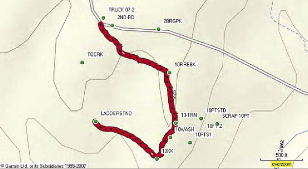
Another benefit is seeing out-of-season pirogue waterways and game trails that are in the grass and bushes that are not normally showing during the actual hunting seasons. Naturally, these pirogue trails, trail junctions, creek or stream crossings and other selected points should be logged in as waypoints in your GPS unit.
Most units allow you to “lay a trail” to and from the stand area. Make an effort now to understand how your GPS unit works. The use of your GPS will give you an insight of the locations of your favorite hunting locations, especially if the unit has internal maps and/or if it can be connected to a computer-based mapping program.
Sometimes these locations are just over a ridge or across a creek, but you thought they were miles apart because you reached them by using a different route. The GPS mapping allows you to “get a lay of the land” and actually see how these locations may interact with one another. The GPS will allow you to choose a more direct route to your area than the one you have previously used to access the area.
If you don’t have a handheld GPS unit and a computer-based mapping program, now is the time to get the items together for your fall hunting season.
Following are some tips that will make your hunting better during the oncoming season.
Let’s start with the GPS unit. Most handheld units have the antenna placed in a coil that is concealed inside the top of the case or have a protruding antenna that may be movable. In order for the GPS to work properly, the antenna must have a clear view of the sky. Even those new highly sensitive receiver units need the antenna to be in a position that offers the best chance of receiving the satellite signals.
The GPS signals are transmitted at a power roughly equivalent to a 50-watt domestic light bulb. The signals pass through space and our atmosphere before reaching your unit after a journey of about 12,500 miles. A broadcast TV signal that is transmitted from a large tower 20 miles away is usually transmitted at a power level of 5,000 to 10,000 watts.
If I wear my GPS receiver in a holster on my belt, the antenna of the unit may be shielded by my body. This may cause the unit to give me an inaccurate GPS position or not work at all.
Remember, if the antenna is covered or concealed by metal or another mass, the signals may not be able to reach the GPS unit. This will cause the unit to lose its position. To get my unit away from my expanding waistline, my wife made a GPS pocket on my hunting vest. The new pocket is located on my off gun shoulder as high as possible. It is in a nearly perfect position to receive the satellite signals. I attach my GPS unit to the vest by a safety pin and its lanyard and a shoe lace. This protects the unit from falling and becoming lost in the event that I stoop over or lean when I am using my climbing stand.
You should start your day by clearing your track log. Either save your important existing tracks that you may later use or delete them from the internal memory of the unit. This will give you a clean slate of new tracks for your present journey in the woods. Be sure that you turn on the track feature after clearing the existing memory. If you are going to a tried-and-true stand, the unit will trace your steps to it. If you have to scout for a stand, the unit will again trace your steps showing the route you chose for getting to the stand.
Next, when you get to your starting point for getting into the woods, turn your unit on and mark the position as a waypoint in the GPS. I call mine “Truck,” as the location where my truck is parked, and I begin my trail journey. Of course, any similar name would do so long as you know it is the location where you started. Place the GPS in the highest pocket you have, and start your trail.
If you note special locations such as trail junctions and other necessary points, mark the locations in your GPS as a waypoint. Use an alphanumeric name that would rekindle your memory as to what the name represents. Scrape 2, Our Pond, N Blind, Rub 1, 14 Point, XX cross, Shoot Ln1, 1ST turn, creek X, Ft of hill, etc. would be appropriate for some of your waypoint names.
As you move through the terrain, the GPS will record your movements as a Track, or Trail, depending on the nomenclature of the software in your unit. When you reach your stand area, save the location as a waypoint in your unit. I call mine “STAND-1.” If you are not venturing farther in the woods, save the existing or active track to a file in the unit. This will then give you a fresh track for your return trip. If you can, take a different route or vary your return trip by doing some scouting of the general area. This will give you some different trails to use should the need arise.
After marking your hunting area and returning to your starting point, access the tracks and again save the return track to your starting point.
This will give you two distinct trails or tracks to your hunting area from your starting point.
When your outdoor day is complete, turn the GPS unit off. After returning to your home or camp, transfer the waypoints, tracks and trails to your data transfer program in your computer or to an appropriate mapping program such as the My Topo Terrain Navigator Pro that I use.
This will allow you to view the waypoints and trails on the mapping program. It will allow you to have your waypoints projected on various maps, and with the My Topo program even on ortho-aerial photos.
You may be surprised at the locations you traveled and where your stands are in relation to other features and other stands.
It is worth your time and effort to get the most current information you can for the upcoming hunting season.
Get out now and prepare for the season.

")
