
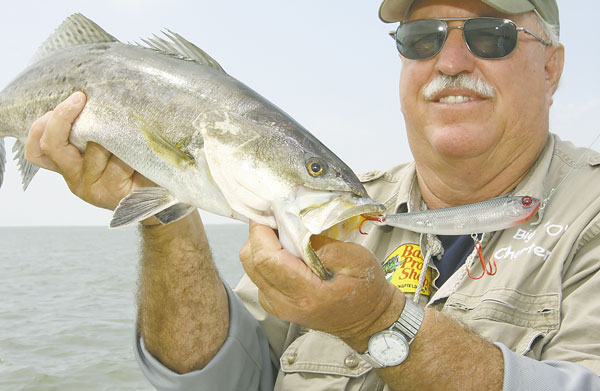


Every April, trout join this water body’s namesake to usher in spring to the Venice area.
Venice is the most intimidating place to fish in all of coastal Louisiana — so much water, so much wind, so many ship wakes, so many dangerous sand bars and mud flats.
But it is the other “so many” that forces every Louisiana saltwater angler to put it on his list of places to visit — so many fish.
Actually, Venice isn’t an actual angling destination as much as it is a launch pad to get to some of the best fishing in the world. Rarely are anglers able to launch their boats and catch fish without having to make 20- and 30-minute runs.
At no time is that more true than during April when the first places to really turn on are the outer lakes and bays all the way down toward the Gulf of Mexico. In fact, the southern ends of these areas are actually defined by the Gulf of Mexico as one seamlessly blends into the other.
Most anybody who has ever read Louisiana Sportsman has heard the big names before — West Bay, East Bay, Garden Island Bay, Redfish Bay and Blind Bay. Anglers are almost forced to fish these outer bays during the spring because of all the muddy water flowing down the Mississippi River. These areas are where the bite out of Venice first turns on every year.
But of all of these, one stands out as typically being the first of the first to turn on. Redfish Bay has lots of stuff going on, which makes it one of the first bays to turn on. According to Capt. Owen Langridge, Redfish Bay is a good one because of its position among the other bays.
“Our main wind through winter is from the northeast, and the way Redfish Bay is carved out, it’s protected from that wind,” he said. “And the water there cleans up faster than other bays because of the combination of salt water coming in from the Gulf and being almost totally protected from a north wind.”
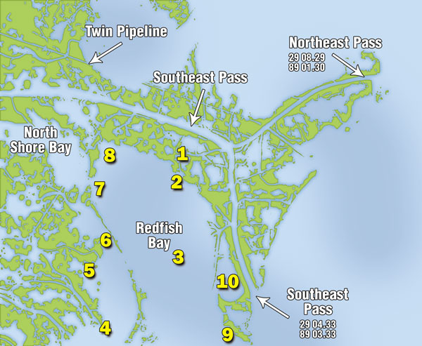
However, Redfish Bay is going to fool some of the anglers all the time and all of the anglers some of the time. Muddy water hides green salt water underneath, and constant current hides the incoming tide rolling in below. You could idle around forever looking for green water to boil to the surface in your prop-wash, or you could just fish these 10 spots.
• No. 1: Apache Camp Cut (N29 7’3.11” x W89 4’55.27”)
This is a natural first stopping point for Langridge as he travels down his preferred path to Redfish Bay through Pass a Loutre into Southeast Pass and into this pass to the west right before Southeast Pass forks into two channels. Langridge calls this pass Apache Camp Cut, and he fishes about a half-mile stretch before entering Redfish Bay.
“This is typically a spot I fish during late fall and early winter for trout that are migrating into the river,” he said. “But they’ll move in here during the spring during little cold snaps. Say the water temperature out in Redfish Bay drops four or five degrees — some trout will move in here to this deeper water and get right in the middle of the cut.”
No matter what time of year he fishes, Langridge says the key here is to fish the bottom, especially on an incoming tide. You won’t see the tide pushing in because of the muddy water continually flowing through the cut, but you can bet green water is bleeding in underneath the mess when the tide is rising.
“I like to throw a black/chartreuse or purple/chartreuse plastic on a 1/4-ounce jighead,” Langridge said. “The salt water will be an 8- to 12-inch zone on bottom, and that’s where your bait’s got to be. I fish from the first curve down to the cut on your right as I fish toward Redfish Bay.”
• No. 2: Apache Points (N29 6’41.47” x W89 5’8.11”)
Before exiting Apache Camp Cut into Redfish Bay, Langridge rarely passes these two points without dropping his trolling motor to give them a quick cast or two. The key here is that the river water flowing out of the cut often brings lots of bait with it, and the trout stack up on the points to wait on a quick meal.
“If you get here early enough, this is an awesome topwater spot,” Langridge said. “Both points are good for a topwater bite, but if you can’t pull them up or you get here late, drag out your popping corks with shrimp baits like Billy Bay Halo Shrimp or DOAs.”
The thing to remember here is that both of these points used to stick a lot farther out into Redfish Bay than they do now. Langridge says they actually stuck out another 40 to 50 yards just a year and a half ago. This means that hitting just the points you can see means you’ll be missing fish on the part of the point that you can’t.
“During the spring, there’ll also be a good mud line on both points when the water out in the bay gets good and green and the river water is still muddy,” Langridge sai. “If that’s the case, fish that line and the backsides of both points. This is a good spot for 2- to 4-pound trout during April and May.”
• No. 3: Old Barge Mooring (N29 6’2.69” x W89 5’41.54”)
Almost right in the middle of Redfish Bay is an L-shaped line of pilings that used be the mooring spot for a barge that has since broken away and washed against a small island to the north. The pilings above the water are only part of the picture, as this entire area is littered with stuff on the bottom.
“Don’t go running in here on plane,” Langridge cautioned. “It’s a little bit deeper here — 3 1/2 feet — than it was back at the Apache Cut, but you’ve still got to be careful. This is mainly a redfish spot for late spring and early summer.”
Langridge says anglers could probably throw Carolina-rigged bait here, but he really sees no reason to switch from his normal black/chartreuse Bayou Chub fished on a 1/4-ounce jighead. Since there is so much stuff to hang on, he brings lots of jigheads. And he tips his jigs with market bait if the water is muddy.
“You’re going to lose some baits here,” Langridge said. “Most of my fish come off the pilings, but you can back off and fish around the outside of the entire area. I catch a lot of bull reds here, but most are in the 20- to 22-inch range.”
• No. 4: Mouth of Loomis Pass (N29 5’35.44” x W89 7’6.99”)
Here, anglers can fish about five or six different points all within just a couple hundred yards of each other. As an added bonus, these points are going to have river water coming through all the surrounding cane, and Langridge says it’s one of the few spots in Redfish Bay that is off the beaten path.
“There’s great topwater fishing here if you get to it early enough,” he said. “I stick with the topwater for the first hour of the morning. All that river water comes through the canes and mixes with the green salt water out in the bay. This spot is kind of a larger version of the Apache Cut with more mixing water.”
Langridge switches to his black/chartreuse and purple/chartreuse Bayou Chubs on bottom after the topwater bite dies. This isn’t as easy as it sounds, though, because this spot has lots of cane stubble on the bottom that will keep inexperienced anglers constantly hung.
“If you’re getting hung, go to the cork,” Langridge suggested. “Set it to where your bait is just a couple inches off the bottom, and you’ll be in the right spot. For some reason here, I catch trout on an incoming tide and redfish when it’s falling.”
• No. 5: Larry’s Point (N29 6’0.06” x W89 7’19.97”)
This is the southern end of a line of marsh that used to separate Redfish Bay and North Shore Bay. Much of it has eroded in just the last couple of years, but there are still a couple of dynamic spots along this old dividing line that offer exceptional fishing.
“You’ll see a big pocket to the south as you approach this point,” Langridge said. “I like to start on the point and fish back into that pocket — mainly redfish here, and almost exclusively market bait under a cork.”
The technique that Langridge likes to use on this point is to anchor and fish a while before picking up and moving to anchor and fish again. He also likes to chum the scattered cane on the point by loading his chum bat with market bait and slinging it to the point.
“You don’t spook the fish that way,” Langridge said. “A lot of water washes across this point on a falling tide, and the fish just stack up on the east side when it’s like that. I stick with the cork because of all the cane stubble, and I set it about 2 feet deep.”
• No. 6: Francois Islands (N29 6’6.19” x W89 7’17.74”)
Immediately north of Larry’s Point lie two small islands that used to be a continuation of this line of marsh. While Larry’s Point is more of a redfish hole, these two islands produce a lot more trout. Langridge typically starts circling about 50 yards away from the islands, and works his way toward them until he finds fish
“Another great topwater spot first thing in the morning, although I don’t throw them a lot here,” Langridge said. “I’ve had my best luck throwing a green Tsunami swim bait or a green Billy Bay Halo Shrimp about 2 1/2 feet under a cork.”
Langridge says there is no rhyme or reason as to where the trout will be on any given day. That’s why he uses the systematic approach of circling his way in. However, it’s easy to pick the right spot with the presence of baitfish or shrimp on the surface
“Also, pay attention to the water behind you as you fish around this spot,” Langridge added. “Sometimes the trout will get out in the open water around these two islands. And fish the little trough between the two islands before you leave because they’ll sometimes stack up there.”
• No. 7: Boola Point (N29 6’47.95” x W89 6’29.48”)
Trout and redfish moving along the northern part of Redfish Bay toward North Shore Bay circle around the tip of this point and set up shop a little while to take advantage of all the bait coming to them in the current of an incoming tide.
“I hate to keep coming back to it, but this point has some great cork fishing,” Langridge said. “We fish a lot of corks down here, but you could also throw some topwaters around Boola Point, too.”
Langridge typically positions his boat on the west side of the point with his rear back in the pocket by two scraggly islands and his front pointing toward the point. This position allows him to cast into the current during an incoming tide and work his baits in a natural way that the fish are used to seeing.
“I like the Halo Shrimp or black/chartreuse Bayou Chub tipped with shrimp,” Langridge said. “And I usually catch my redfish right up on the point and the trout farther out away from it. The thing here, though, is that you can catch some really good bull reds right on the point.”
• No. 8: The Barge (N29 6’52.66” x W89 6’8.10”)
This is the barge that broke away from the mooring mentioned earlier in the second spot. As it pushed toward the north after Hurricane Katrina, the barge jammed against a small island where it still lies today. The barge is clearly visible on post-Katrina overhead maps and Internet satellite imaging.
“Redfish love this barge during the spring because the water is two or three degrees warmer around it than out in the bay,” said Langridge. “They don’t really stack up on it, though. Rather, they push along the side of it as they patrol the bank. But they always stick around it just longer than they would just a bank.”
Langridge says the typical scenario is for him to fish it for several minutes before getting a bite that begins a string of more bites. Then it dies down for a while until more redfish move in.
“For me, this spot is strictly market bait under a cork,” he said. “I’m expecting only redfish, so I give them something I know they’re going to hit when they swim by. You’re wasting your time here during the summer, though. Fish it in March, April and May.”
• No. 9: Allen’s Point (N29 5’38.77” x W89 4’28.04”)
This point is at the southeast corner of Redfish Bay just below the mouth of Southeast Pass. To the west of the point is Redfish Bay, and to the east is the Gulf of Mexico. Its proximity to the Gulf is what makes this a very good spot for picking up fish when other spots fail.
“Before Katrina, there was a sand bar that ran way off this point,” Langridge said. “You could see the breakers on top of it, and you couldn’t motor across it. That’s gone now, but it’s starting to build back up. And there’s one little trough in the new sandbar that can hold some really good fish.”
Langridge drifts the west side of this point and throws out a chain anchor when he gets on the fish because the bottom is too sandy for his Power Pole to hold. And he bases his fishing techniques on whether he’s after trout or redfish.
“For trout, I fish under a cork with either DOA shrimp or Billy Bay Halo shrimp,” he said. “If I’m after redfish, I go with the black/chartreuse plastic on bottom. There’s not much cane stubble here, so you can fish bottom. The thing here is you’re either going to catch bull reds or trout; you’re not going to catch both.”
• No. 10: Brent’s Pocket (N29 6’ 2.55” x W89 4’ 20.58”)
Just north of Allen’s Point is a decent-sized pocket that gets really shallow around its perimeter. Langridge says it is the ideal spot for quickly catching a bunch of school trout around 16 inches because of the way it’s protected from the east and southeast winds.
“I get right against the canes and throw back out into the pocket,” he said. “I rarely do any good getting in the middle and fishing toward the banks. It also has two good points leading into it, but I hardly catch fish there either — all in the middle.”
Langridge hits this pocket with DOA and Halo Shrimp under a cork during April and May, but he switches over to live shrimp during June. The water has a tendency to get gin clear if the wind isn’t blowing that time of year, and it gets hard to fool them with anything but the real deal.
“Man, you can whack on them here,” Langridge said. “It’s not a big-trout area, but boy do the keeper trout stack up. When I get on the bite, I stick my Power Pole in the mud along the cane, and sit there and work on them as long as they’ll bite.”
Contact Capt. Owen Langridge at 225-978-1136.


")