


Scout out exposed structure during drawdowns to increase your catch for years to come.
It was one of those perfect days for catching white perch — cold, overcast and a light wind.
After making the long drive from West Monroe to Saline Larto, I found that every fisherman in Central Louisiana must have had the same thought. The bayous were crowded with people, all of whom were drifting in the middle of the channels seeking deep fish feeding on schools of shad. Everyone, that is, except one.
An elderly man in a beat-up johnboat was off by himself easing down the bank dragging a small jig in water not deeper than 6 feet. Obviously, he had not read the memo that crappie gang up in deep water during the winter.
Most of those in the channel were pulling up fish on a regular basis, but the crappie were all dinks that were too small to keep. The old man, on the other hand, would snag a slab every 10 minutes or so, and wrestle it into his net.
When he got to a certain point, he would turn around, go back down the bank and catch another one. For an hour, I watched him go back and forth over a stretch of water about a hundred yards long.
It’s always interesting to be in a crowd of fishermen when one person is out-catching everyone else. First, there are the long stares, then murmurs and head nods toward his direction and finally boats are drawn to him like light to a black hole to get a closer look at what he could possibly be doing different.
Being as curious as anyone, I slipped in some distance behind the old man, and checked my depth finder to see if maybe he was fishing a drop-off. There was none.
Finally, he cranked up and left, and I quickly eased into his place.
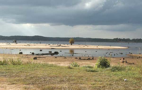
Almost immediately I had a good fish on. I caught several nice white perch in that stretch of water, but also got hung up on occasion. It was not until the water level dropped about 5 feet in Saline-Larto the next year that I discovered the secret.
Hurricane Gustav caused a levee breech that allowed much of the water to drain out. When I went down to take some photographs for an article I was writing about the incident, I motored past the fishing spot.
That short stretch of bank had two submerged tree tops that obviously concentrated the fish. While looking at the now-exposed structure, I had an epiphany.
Many Louisiana lakes undergo periodic drawdowns to help control aquatic-plant growth, maintain the dam and spillway or allow property owners to work on their piers and boat launches. Others, such as Toledo Bend a few years ago, drop dramatically because of drought conditions.
Why not use the opportunity to scout the exposed lake bottom for hidden structure and features that are normally unseen?
My Humminbird 383C fish finder has a GPS feature that can be used to save coordinates. I could cruise the Saline-Larto complex, and punch into the unit any features I found that would be covered up when the water rose again.
Over a two-day period, I moved up and down the labyrinth of bayous, keeping a sharp lookout for stump fields, lines of stumps along the bank, logs, treetops, drop-offs and anything else that might hold fish and be invisible when the water came back up.
When I found what I was looking for, I eased the boat next to the structure, saved the spot on my Humminbird unit and then recorded it in a small notebook. Next to the site number, I made detailed observations about the place.
For example, if there was a good jumble of branches off to one side of the main trunk instead of at the end, I wrote it down. And to save time and not have to log in every single structure, I noted if there was another one within 50 yards of the one I recorded.
Two of the notations read: “007: tree top, angles to the left and extends about 15 yards from the bank. Another tree top 30 yards past it as you go toward Horse Island.
“008: tree top located just out from the three cypress trees. Best branches are even with the tree’s outside limbs and run parallel to the bank for 15 feet. Another top located 20 yards to the left, closer to the first cypress tree in the next group.”
Writing down such details can come in handy later. When the water comes back up, you can often see the tree trunk on the bank, but if you didn’t know the main limbs were to the left or right of it, you might waste time fishing in the wrong spot.
I went back and tried 008 several months later. There was absolutely nothing to indicate a tree top was located there, but I caught three nice white perch and lost several more by dropping my jig right where my notebook said the top was located.
Harold Taylor, owner of Uncle Bud’s campground on Larto Lake, is an avid crappie fisherman who also took advantage of the low water to do some scouting.
“I look for treetops, drop-offs, ledges and other sorts of features,” he said. “All of them can hold sac-a-lait at certain times of the year. Sometimes you want to find the drop-offs into a deeper channel because that’s where the fish will hang out.
“I prefer stumps along a drop-off, but if you have a pretty wide shelf before the drop off, that can be good, too, because the sac-a-lait will move back and forth between the deep water and shallow shelf to feed.”
Taylor points out that numerous logs are visible on the bank when the water is at pool stage, but you have to stop and fish each one to find the ones that are most productive.
“If a tree has very few limbs on it, I’m not going to fish it much,” he said. “I want to find the ones with lots of limbs underneath the water. That’s the kind that will hold fish.”
By scouting when the water is down, you can find such treetops and not waste time fishing the bare logs.
Hidden treetops are not the only good crappie spots, Taylor noted.
“I’ve also gone out to plot some of the stump fields that you would never know were there if the water had not gone down,” he said. “Those fields can be good places to fish during the sac-a-lait spawn.”
Taylor has a great fish-finder that helps him in his scouting and allows him to return to his marked spots.
“I have a Humminbird with a built-in GPS and side-scan sonar,” he said. “You can go about a half mile an hour, and see stump lines and treetops off to the side, but you can’t always tell how many stumps.
“Now that the water has gone down, I’ve gone back to verify the unit’s accuracy, and have found they’re all right there where there supposed to be. I can also get a more-accurate look at what’s actually there.”
Even if you don’t have a GPS unit, such scouting trips can still pay off. I did it way back in the 1970s when such technology was not available.
When I was a graduate student at Louisiana Tech, Lake D’Arbonne was drawn down about 7 feet one summer. I often fished west of Highway 33 around the Tech Camp, but the low water exposed something I never knew was there. Standing on a hill overlooking the lake, I could see what appeared to be a small pond with cypress trees a few hundred yards off the main channel.
Over the next couple of months, I frequently went to the lake after class. After paddling across the channel, I would wade through the muck to fish the pond. It was full of trapped bass, and I almost always caught a limit working a floating worm across the surface.
On one trip, I caught a 6-pounder, which is still my largest bass. After the lake filled back up, I continued to fish the deep hole, and enjoyed good success.
A few years later while living in Natchitoches, I was involved in some archaeological projects under Pete Gregory at Northwestern State University when the old Allen Dam on Black Lake collapsed and the lake drained out.
Over several months, I made numerous trips to the Clear Lake/Chivary Bay area looking for Indian sites that may have been exposed by the low water. Not only did I discover some sites, I also began to notice evidence of huge bream beds around the cypress “islands” on that part of the lake.
These islands have always been popular bream fishing spots, and I frequently dunked crickets around them. But it was not until they were exposed after the dam break that I understood the topography and made an interesting discovery.
The islands are small sandy bumps on the lake bottom. While walking around them, I found some areas were literally covered with the dish-plate depressions of bream beds.
What surprised me was that the beds were not among the cypress trees where I always fished, but out from them a ways in what would normally be open water. I always picked up some bream on my trips, but if I had known the location of the beds, I would have concentrated in a completely different area and probably filled ice chests.
When such beds are discovered, you can target them year after year because bream use the same bedding areas over and over.
Austin “Ox” Belgard is another fisherman who scouts lakebeds without the aid of a GPS. He has a camp on Saline-Larto, and loves to fish for the big bull bream that complex is noted for. When the water drained out last year, he and a friend spent an entire weekend looking for new places.
“My buddy and I are always on top of the bream action, and with the water so low, we wanted to see if we could find some beds we hadn’t found and see how deep they went,” he said. “Once we got out there, we started looking for structure that the crappie and bass would like. We were blown away at how much was exposed that we had no idea was there.
“I looked for areas with exposed stumps that were usually a few feet under water. We found a few small flats loaded with stumps and sunken logs. We even found a few PVC crappie structures like I’ve seen made on crappie-fishing websites.
“Mostly the stumps we found we had no idea were there. In the bayou going to the Government Cut from my camp, I found that the channel split in a curve at one point and left a small shallow strip of stumps only a few feet deep at normal water stage. A friend of mine went back and caught catfish and bass off that spot. The old-timers all knew about that stuff, but I had no idea.
“During the spawn, I hit several of the little holes we found, and did very good. In one little bayou, I caught over 50 crappie in a week’s time just going for a couple hours after work. It was very, very shallow. I couldn’t get back in it very far, but I found an area in about a 6-foot circle with some small stumps scattered about and a sunken log. I tied a piece of flagging in a tree to mark it. I never would have thought to fish it if I hadn’t gone scouting while the water was down.”
Even without a GPS, Belgard found it easy to keep track of his new fishing spots.
“I took lots of pictures, and we had a map of the entire Saline-Larto complex. On the sections of bank where we found things, we shaded in different colors on the map and wrote down about how deep to fish when the water is at normal level.”
If you do have a GPS unit, Google Earth can be used to create similar maps. Punch in the coordinates in latitude and longitude, mark them with the thumbtack icon, label them with a name and print out the satellite photo to keep with you when you’re fishing.
Whether you’re high-tech or not, taking time to scout out lakes during drawdowns will pay off for years to come.


