The Baton Rouge area offers plenty of public ponds that present anglers young and old the opportunity to fill their stringers.
GPS has been heralded as the best-yet man-made navigation system, but the internal features have been lacking when compared to current technology in cellular phones, iPods, Blackberry devices, computers, wireless laptops, satellite phones and televisions. These shortcomings are new being addressed for the GPS user by a variety of manufacturers.
Yes, even the casual hunter, angler and auto traveler knows that GPS receivers are an outstanding means of providing the user with accuracy in finding locations and navigating in strange or complicated areas such as the myriad of coastal waterways and marshes.
Modern GPS units can deliver a position accuracy within 3 meters (9.8 feet). The consumer has long had the ability to install such GPS receivers in autos, motorcycles, RVs, airplanes, ATVs and boats, as well as carrying them as handheld units in almost any environment. Those that are exposed to the elements are usually shock-resistant and weatherproofed to very exacting standards. They can have color screens, and most can display some sort of map images on their various screens.
The touch-screen control functions are now finding their way into a variety of GPS receivers. There are no or very few buttons to press; you simply touch the screen and access your menu features. You can now purchase GPS units with touch-screen command features, wireless connectability to other units, marine radios and cellular phones and with very detailed maps.
Some of the improvements are still in the works, while some of the new technology is now available.
The greatest concern about GPS features that I hear from readers is about the internal maps. The concern is that they are not up-to-date, and are a poor rendition of the actual topography.
It is this mapping feature upgrades that I will explain in this segment.
Old technology
The concern comes about the type and accuracy of the maps that are available for use in these receivers — not the accuracy of the GPS system, but how the topography is displayed on the screen. There is a great advantage in having an accurate map available in the unit that is interphased with the various other functions and screens found in GPS receivers.
This is not to say that you depend solely on the internal map, as the GPS system may crash or be lost. Users want the clarity and detail that are offered by actual hard-copy topo maps, marine charts and aerial photo maps available in their GPS receivers. Past technology prohibited this because of a unit’s memory requirements. The required memory capacity of such type of mapping exceeded the technology capacity of the memory cards.
Sometimes I almost had to chuckle at users’ complaints, as I can remember only a few short years ago when we were considered lucky to even have a map of our fishing or hunting areas.
Those of us who took the time to get an official U.S.G.S. topo map and knew how to use it were considered the elite of the outdoor team. Most of these individuals always had a tag-along companion or two who was afraid of getting lost in his bathtub. Finding your way with a map and compass is an accomplishment in itself. Ex-military personnel who were hunters and anglers were always welcomed companions, as most of them learned orienteering in the military.
GPS has now made everyone an accomplished pathfinder.
In the past, most GPS receivers had a limited amount of internal mapping memory, and could only use the maps that were designed for the particular unit. The state-of-the-art technology just a few short years ago consisted of memory capacities ranging from 20 to 60 MB. And even some of these memory banks needed constant electronic current to preserve their data from one start up to another. GPS receivers of this vintage had to have internal batteries in addition to those needed to operate the other GPS functions, just to keep the data “alive.” These batteries were usually sealed in the cases, and could only be serviced by factory service centers.
Those of you who have older digital cameras and other such electronic devices know that the memory cards were about 2×3 inches in size. One that had 32MB of memory was considered to be an electronic marvel.
Memory cards in these sizes restricted the types and sizes of the available mapping data. The maps that were used in these GPS devices were usually computer re-drawn versions that were derived from existing official National Oceanic and Atmospheric Administration (NOAA) marine charts or from U.S. Geological Survey (USGS) topographical-type maps.
These map images were redrawn in order to reduce the size of the data that made up the mapping images. They had to fit in the allotted space of the memory bank and still fit in the GPS housing of the unit. These redrawn maps did not have all of the map features of the official maps and charts of the same areas. This scaled-down mapping software was then able to fit in the allocated memory space of the GPS unit. Some of the older units had these memory cards sealed inside, and they were only accessible via download from a computer.
New technology
New mapping features that include actual images of U.S. Geological Survey (U.S.G.S) topographical maps, NOAA charts and ortho-aerial photo maps in several formats are now available in some manufacturers’ newer units.
This is now possible because of new-technology memory storage devices. Today there are micro-secure digital memory cards that are the size of the fingernail of your little finger, and secure digital cards the size of a postage stamp that are available in unheard-of memory sizes.
Cards are now common that have memory of 8GB (8,000MB) or larger. As of this writing, standard postage stamp-size SD cards can be found with a memory capacity as large as 32 GBs.
Realizing the capacity memory banks now available in the technical world, many GPS manufactures started incorporating these memory features in their lines of GPS receivers and sonar units.
Forward-thinking manufacturers have designed their units to allow the user to “plug in” or insert these memory cards into waterproof receptacles in the GPS unit. That means that technology involving the memory capacity of the mapping images and features on these maps has increased over 1,000 times in just a few short years.
The older receivers would have maps that would cover an area of 30 x 60 miles (1,800 square miles) of the manufacturer’s mapping software. That meant the user could actually travel a distance into an area that would not have the necessary maps installed in the unit. The user would actually travel off of the area covered by the existing maps in the unit. This was especially true when using actual aerial photo maps. The amount of digital data required to display a 4-x-6-mile area is enormous.
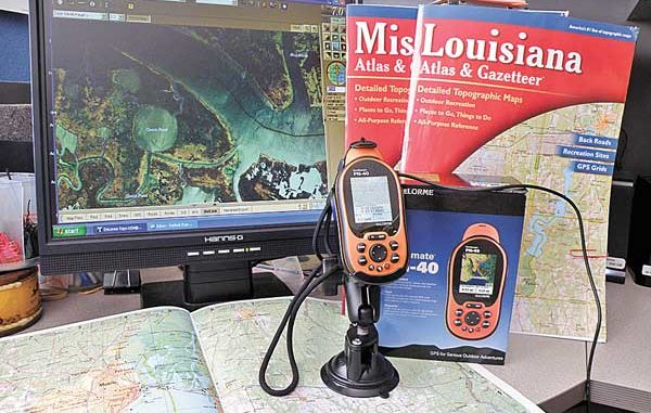
DeLorme rises to challenge
Other newer units of some manufacturers have the ability to read and display data from a 1 or 2GB card. However, one manufacturer that has designed its GPS receivers to take advantage of the new high-speed map memory cards is DeLorme.
The DeLorme PN series units can read a 32GB high-speed memory card. An area that is 800 x 1,000 miles of the computer-drawn maps and about 600 x 800 miles of actual U.S.G.S. topographical maps can be loaded in these memory cards. In the Delorme PN-40 unit, USGS topographical mapping of the entire state of California requires about 1 GB of card memory. One GB of memory for their computer-redrawn maps would cover almost two and a half states the size of California.
Color ortho-aerial photo maps (DOQQ), because of the enormous details in the images, naturally require more bytes of memory. But with a unit that can read 32 GB of data, you can have more than enough of the maps you need for one trip of almost any area.
This advance in memory technology now allows the GPS user to have an area that can include nearly a complete state in an onboard mapping repertoire. In addition, the units can now contain actual images of NOAA charts, ortho-aerial photos in several different formats and U.S.G.S. topographical maps with supplemental data shown or not shown depending on the needs of the user.
Best of all, you can have them all in the unit at the same time, and swap between the types you need. While the present technology cannot yet accommodate a complete three- or four-state area of such highly detailed ortho-aerial photo maps, the fact that the cards can be removed from the unit means that the user can have several cards preloaded with the necessary maps.
DeLorme is an established producer of fine GPS Earthmate receivers, Atlas, Gazetteers and computer-mapping software that has been on the consumer market for years. DeLorme Topo USA software, which is available on DVD, has up-to-date, detailed DeLorme maps that include over 3 million updated roads, plus the latest terrain and trail data. Some of these updates are roads that don’t even appear in the latest government maps.
The DeLorme Topo USA software offers superior program capabilities, resolution and performance by itself. But one of the most outstanding features of the program is that it can access the DeLorme database of maps via a NetLink download feature that covers all NOAA marine charts and USGS satellite, aerial and color aerial photo maps.
The 7.5-minute quadrangles consist of more than 55,000 such topo maps that cover the 48 continental states, and it also has coverage of Alaska and Hawaii. The topo mapping is the uniform map series that covers the entire area of the United States in considerable detail.
The program requires a Microsoft Windows XP or 2000 (Service Pack 3 and higher) operating system and at least 128 MB RAM.
DeLorme has also designed a “PN” line of handheld units. They offer a “best-value” model called the PN-20 that can use DeLorme’s Topo USA. Although the PN-20 has most of the features that the casual GPS user wants, the PN-40 is the top-of-the-line unit. It is the one I opted for.
DeLorme provides a start-up of downloads for the program worth $40, but the way to go is to subscribe to their Map Library Program that is presently only $29.95 a year. The yearly subscription offers unlimited downloads of all of their different types of mapping. You simply select what type of map you want to view, access the DeLorme web via the NetLink procedure in the Topo USA program and select the rectangle boxes of mapping you wish to have installed in your computer. Some of these downloads can take up to 10 to 15 minutes apiece using a broadband internet connection, so you don’t wait until the last moment to do your download and transferring the map images into your GPS receiver.
DeLorme even configured a neat feature that allows the PN-40 to be powered through the included USB cable when connected to your computer. The USB connection provides power for the unit as well as making the connection possible.
For those who need or want the latest technology in a GPS receiver along with the latest official NOAA charts, USGS topo and aerial photo maps, this is one of the best ways to have it all in a rugged, concise handheld GPS receiver.
The entire line can be viewed at www.delorme.com or be described via telephone at (800) 561-5105.


")