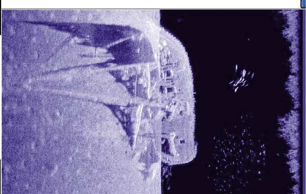
The basic principles of sonar are tied to the laws of physics and can’t change much, but Humminbird’s Side Imaging feature proves that sonar’s application to sportfishing is still evolving. Careful scanning produces underwater views out to the sides of your boat that rival black-and-white photos. Grainy photos perhaps, but much easier to understand than screen pictures derived from conventional vertical sonar scanning.
The remarkable detail comes from the shape of Side Imaging’s side-looking beams. Each time they make a sounding, the Side Imaging transducer elements scan a thin, vertical slice of water that is tall from top to bottom but very narrow from side to side. The knife-thin slice of water covered by each sounding starts almost at the surface straight out from your boat and extends downward to within 10 to 15 degrees of vertical.
The results from consecutive soundings are merged into a picture with surprising resolution. The side scans show objects in their actual shape and location relative to the boat. Rocks look like rocks, bridge pilings look like bridge pilings and, yes, fish look like elongated, almost tubular objects.
Conventional vertical sonar, in comparison, must look at a three-dimensional circular area and compress everything into a two-dimensional screen picture. Individual objects appear as rounded blobs, and there is no way to tell where they are inside the transducer’s circle of coverage.
I have seen recorded screen pictures of a submerged automobile that clearly showed which direction the front wheels were turned, pictures of the top of a submerged dam in which you could count the spokes in a control wheel and a shot of a sunken sailboat with the masts and a considerable amount of deck detail easily discernable.
Achieving such detail cannot be done without observing a few rules. Side imaging works best with the boat moving in a straight line at a constant slow trolling speed between about three and five miles an hour. Varying your speed can vary the consistency of your screen detail because parts of the picture recorded at higher speeds may look different than parts recorded at lower speeds.
Traveling in a straight line is important, because as your boat turns, the consecutive slices of water scanned to the outside of the turn become spread out, leaving gaps between them while the slices on the inside of the turn overlap each other. Both situations distort the screen picture.
Side Imaging can be done at either 455 or 800 kHz. The lower frequency covers more water, it scans almost straight out just below the surface of the water and reaches farther from the boat. The higher frequency scans a slice of water starting about 15 degrees below the surface and has less range. 800 kHz is capable of better detail, but it may give you too much of a good thing. It sometimes delivers dense readings that appear darker and are more difficult to interpret.
I use 455 kHz almost exclusively. It doesn’t hurt to switch back and forth to see which frequency does best under certain conditions. You can also vary the sensitivity level and chart speed to custom-tune your screen picture.
It’s easy to interpret the screen picture once you grasp its perspective. Imagine yourself up in the air above the area being scanned and looking down at it. The area looks like it is being illuminated by a bright light shining sideways from the transom-mounted transducer. The sides of suspended objects and bottom structure facing the transducer turn bright white and can be hard to see, but these objects cast a shadow on the bottom sharp and clear enough for you to count the branches in the trees and the fish in a school.
The Side Imaging feature lets you record snapshots of the current screen picture or record the scrolling sonar image on plug-in memory cards. You can share great views with fishing buddies and have confusing screen views explained by experts. For more information, visit humminbird.com or call (800) 633-1468.
The 987C has an impressive GPS mapping capability that can use Navionics Gold Charts and Navionics HotMaps Gold cartography for Great Lakes and other inland waters. Dual microprocessors provide fast, full-screen sonar and chart updates, and allow the three-channel sonar transmitter/receiver to manage its four frequencies.
A wide, high-resolution color screen has plenty of room for split-screen views, and a fisherman friendly, two-stage menu system manages all functions.
One of the unit’s top convenience features is a set of three programmable soft keys. You select a combination of sonar and GPS screen views and feature settings, press one of these keys, and it remembers all your settings. Every time you press that key, it brings back the same combination of screen views and feature settings. You use one key to set the unit up for shoreline fishing, one for downrigger fishing and one for navigation.
How often have you wondered while trolling if the mother lode of fish was just far enough to the left or right of your spread to ignore it? The advantages of seeing fish, baitfish and structure 240 feet to either side of your boat are obvious, but other advantages are not. I asked Jimmy Bell, a veteran pro angler, what he’s discovered in a year of using the 987c on the walleye circuit.
Bell said pros often look for forage instead of fish. On Lake Erie, for example, schools of fish suspend and move across great expanses of open water. He scans to both sides at maximum distance looking for suspended schools of smelt. Find the forage, and fish will be close by.
When he sees a ball of bait off to the right or left, he can adjust his planer boards to pass over them. He can also move an on-screen cursor to the indicated school and mark it as a waypoint. Then he can turn around, switch half the screen to a chart and troll right back over the forage.
Bank fishermen on Lake Michigan this last summer told Bell about a great spot off a rip-rapped shoreline. He side-scanned it and instantly spotted the reason for its extra attraction. When the rip rap was created, an extra load or two was dumped there, forming a point of gravel and rock sticking out into the lake in around 20 feet of water.
While fishing Chequamegon Bay for smallmouth bass, Bell discovered fish sitting right on the transition areas between rock and soft bottom. The side-imaging feature showed him the breaks between the boulders and soft bottom, letting him position his boat perfectly to cast to the fish.
Bell put together a successful trolling pattern along submerged tree lines. Trees eat lures, and with down-looking sonar, you would practically be in the trees before you could read them. Side imaging let Bell troll his crankbaits in clean water next to the trees where the fish would come out and hit them.
Bell discovered that side imaging lets him see each post supporting a pier or dock, and any fish sitting under them. He was able to identify the docks that held fish on tournament practice days without having to catch them to make sure they were there.
The basic principles of sonar are tied to the laws of physics and can’t change much, but Humminbird’s Side Imaging feature proves that sonar’s application to sportfishing is still evolving.
Careful scanning produces underwater views out to the sides of your boat that rival black-and-white photos. Grainy photos perhaps, but much easier to understand than screen pictures derived from conventional vertical sonar scanning.
The remarkable detail comes from the shape of Side Imaging’s side-looking beams. Each time they make a sounding, the Side Imaging transducer elements scan a thin, vertical slice of water that is tall from top to bottom but very narrow from side to side. The knife-thin slice of water covered by each sounding starts almost at the surface straight out from your boat and extends downward to within 10 to 15 degrees of vertical.
The results from consecutive soundings are merged into a picture with surprising resolution. The side scans show objects in their actual shape and location relative to the boat. Rocks look like rocks, bridge pilings look like bridge pilings and, yes, fish look like elongated, almost tubular objects.
Conventional vertical sonar, in comparison, must look at a three-dimensional circular area and compress everything into a two-dimensional screen picture. Individual objects appear as rounded blobs, and there is no way to tell where they are inside the transducer’s circle of coverage.
I have seen recorded screen pictures of a submerged automobile that clearly showed which direction the front wheels were turned, pictures of the top of a submerged dam in which you could count the spokes in a control wheel and a shot of a sunken sailboat with the masts and a considerable amount of deck detail easily discernable.
Achieving such detail cannot be done without observing a few rules. Side imaging works best with the boat moving in a straight line at a constant slow trolling speed between about three and five miles an hour. Varying your speed can vary the consistency of your screen detail because parts of the picture recorded at higher speeds may look different than parts recorded at lower speeds.
Traveling in a straight line is important, because as your boat turns, the consecutive slices of water scanned to the outside of the turn become spread out, leaving gaps between them while the slices on the inside of the turn overlap each other. Both situations distort the screen picture.
Side Imaging can be done at either 455 or 800 kHz. The lower frequency covers more water, it scans almost straight out just below the surface of the water and reaches farther from the boat. The higher frequency scans a slice of water starting about 15 degrees below the surface and has less range. 800 kHz is capable of better detail, but it may give you too much of a good thing. It sometimes delivers dense readings that appear darker and are more difficult to interpret.
I use 455 kHz almost exclusively. It doesn’t hurt to switch back and forth to see which frequency does best under certain conditions. You can also vary the sensitivity level and chart speed to custom-tune your screen picture.
It’s easy to interpret the screen picture once you grasp its perspective. Imagine yourself up in the air above the area being scanned and looking down at it. The area looks like it is being illuminated by a bright light shining sideways from the transom-mounted transducer. The sides of suspended objects and bottom structure facing the transducer turn bright white and can be hard to see, but these objects cast a shadow on the bottom sharp and clear enough for you to count the branches in the trees and the fish in a school.
The Side Imaging feature lets you record snapshots of the current screen picture or record the scrolling sonar image on plug-in memory cards. You can share great views with fishing buddies and have confusing screen views explained by experts. For more information, visit humminbird.com or call (800) 633-1468.
The 987C has an impressive GPS mapping capability that can use Navionics Gold Charts and Navionics HotMaps Gold cartography for Great Lakes and other inland waters. Dual microprocessors provide fast, full-screen sonar and chart updates, and allow the three-channel sonar transmitter/receiver to manage its four frequencies.
A wide, high-resolution color screen has plenty of room for split-screen views, and a fisherman friendly, two-stage menu system manages all functions.
One of the unit’s top convenience features is a set of three programmable soft keys. You select a combination of sonar and GPS screen views and feature settings, press one of these keys, and it remembers all your settings. Every time you press that key, it brings back the same combination of screen views and feature settings. You use one key to set the unit up for shoreline fishing, one for downrigger fishing and one for navigation.
How often have you wondered while trolling if the mother lode of fish was just far enough to the left or right of your spread to ignore it? The advantages of seeing fish, baitfish and structure 240 feet to either side of your boat are obvious, but other advantages are not. I asked Jimmy Bell, a veteran pro angler, what he’s discovered in a year of using the 987c on the walleye circuit.
Bell said pros often look for forage instead of fish. On Lake Erie, for example, schools of fish suspend and move across great expanses of open water. He scans to both sides at maximum distance looking for suspended schools of smelt. Find the forage, and fish will be close by.
When he sees a ball of bait off to the right or left, he can adjust his planer boards to pass over them. He can also move an on-screen cursor to the indicated school and mark it as a waypoint. Then he can turn around, switch half the screen to a chart and troll right back over the forage.
Bank fishermen on Lake Michigan this last summer told Bell about a great spot off a rip-rapped shoreline. He side-scanned it and instantly spotted the reason for its extra attraction. When the rip rap was created, an extra load or two was dumped there, forming a point of gravel and rock sticking out into the lake in around 20 feet of water.
While fishing Chequamegon Bay for smallmouth bass, Bell discovered fish sitting right on the transition areas between rock and soft bottom. The side-imaging feature showed him the breaks between the boulders and soft bottom, letting him position his boat perfectly to cast to the fish.
Bell put together a successful trolling pattern along submerged tree lines. Trees eat lures, and with down-looking sonar, you would practically be in the trees before you could read them. Side imaging let Bell troll his crankbaits in clean water next to the trees where the fish would come out and hit them.
Bell discovered that side imaging lets him see each post supporting a pier or dock, and any fish sitting under them. He was able to identify the docks that held fish on tournament practice days without having to catch them to make sure they were there.


