Dear Capt. Paul:
A friend of mine advised me not to carry my GPS handheld unit while hunting, as he claims that his smart phone can provide all the information that he needs. What about maps? Where can I get some hard copy ones? What is your view on this and why?
—Rodney W.
Capt. Paul’s response:
Wow. I must really commend you for wanting “hard copy” maps of the areas you will be traversing. It is one of the items that I strongly recommend in my seminars. Too often people are depending more and more on electronic devices that have the probability of failing. Without having a backup, you could be in trouble.
I have personally had all of my GPS data in my unit erased when lightning struck during a thunderstorm near my boat. Not only did it scare the daylights out of me, it wiped out all of my tracks and waypoints, and it also erased mapping images on my map card. I was able to get the unit working again, but I had to manually enter some of the crucial navigational waypoints. I retrieved these waypoints from a printed copy of all of the waypoints in my unit. Having a hard copy of a map of the area and a hard copy of the waypoints saved my trip. Remember that a chart/map and compass allowed navigation for hundreds of years. You should always have a backup system to get you home.
About your mapping requests: The official ones for marine use are the NOAA – Office of Coast Survey marine charts. These can be viewed on their web site at http://www.charts.noaa.gov/InteractiveCatalog/nrnc.shtml This site allows the reader the ability to download a file (.pdf) on a computer as a file which can then be printed. The size of the printed chart will be determined by your computer’s printer. And it will most likely be on standard paper.
Another option is to visit an Office of Coastal Survey contact mapping store. Any competent mapping store should be able to print some of these for you. These are contract stores that have a computer link to the Office of Coast Survey – NOAA. These stores actually print the charts for you on a plastic type “paper” that is ideal for marine use. You can obtain the locations of these dealers from the NOAA web site at https://www.nauticalcharts.noaa.gov/pod/index.html
Land use/USGS topographical maps
As for land use maps, there are no better than the Unites States Geological Survey (USGS) topographical maps called “quads” and/or “topo.”
These are the foundations that most map makers use to produce their own maps. They are can be located at the USGS site at https://www.usgs.gov/products/maps/overview
For these topo maps another site is the MYTOPO at https://www.mytopo.com/maps/ This site allows the viewer to view one or several USGS topo maps as one map. It allows the user to configure a standard size topo taking parts from topographical maps that join each other to make a single map. You can even zoom in and out to change the scale of the map. These maps are printed on a foldable plastic “paper” with water resistant ink. Along with a compass, they are a great backup tool.
As note, sometime a USGS topo maps at 1:2400 scale is superior to a 1:80,000 NOAA chart for showing mapping details away from the commercial waterways. There are many such areas in the Louisiana coastal marshes.
Smart phone or GPS unit?
I have gotten many questions concerning this issue. And I realize that my choice may not be for everyone, but it is my feeling on this matter.
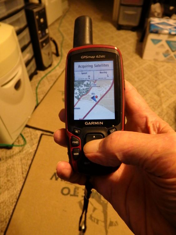
I suggest that you use the Global Positing System (GPS) unit rather than a smart phone for navigating in the outdoors. My opinion would apply to both handheld and a marine-mounted device.
I’ll give you my thoughts on the matter so that you can make an intelligent decision for yourself.
First, most GPS units are designed to meet or exceed a weatherproofing standard of XP-7. This means that the unit will endure submersion in water up to 3 feet deep for a half hour. That means that you could use the unit in the rain without fear of it being damaged. This is a real advantage over a smart phone or pad, as most have warnings to limit their use in severe weather. Yes, I know you can place the smart phone in a plastic zip-type bag, but then you may not be able to operate iy with the touch features while wearing gloves, etc.
FCC regulations require that wireless phones (cellular) have a GPS radio chip, and that theycan transmit the caller’s location on any emergency calls made to 911.
However, these GPS functions in a smart phone usually let the operator use some GPS functions that are in standard GPS unit.
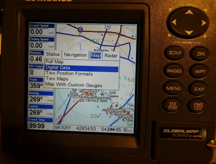
A standard GPS unit will have several different screen formats. Some have as many as nine different screens, which have differently shown GPS formats and data terms. These screens can be tailored to show all kinds of maps and navigation data, such as time of arrival, time in route, distance to next location, heading, course, course up, track, tracks up, north up, routes, speed, compass info, off track and many more. These features allow you to safety navigate and to get the most out of the GPS system.
In addition, the smart phone must receive signals from a cell tower or a Wi-Fi source. Most towers are placed about 5 to 8 miles apart to provide overlapping areas of coverage. The phone and tower are constantly connected via radio burst signals. That tower coverage is called a cell area, thus the cell phone designation.
If your smart phone is between tower coverages or cannot receive a Wi-Fi signal, such as in a canyon or such other obstruction, it cannot receive any of the date and map images. This means that you would not have updated images or features or many of the other applications (APPS) that are available in the smart phone when a cell tower is not in radio range.
But a GPS unit has all of its features installed as software memory. This would include the mapping images, which are either in the software or on a supplemental mapping data card.
Most GPS units now have an accuracy supplemental program called WAAS. This increases the accuracy of the GPS to an average of three (3) meters (9.8 feet). The standard GPS accuracy is about 20 meters. This accuracy could be a great help in finding a honey hole or tree stand in the woods.
I know that the smart phone/pad is state of the art for what it does, but I believe that a true GPS unit has many more features and will work better in the great outdoors.
—Capt. Paul